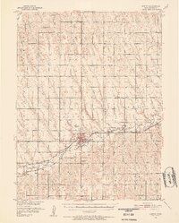
1951 Map of Norton
USGS Topo · Published 1952About this map
Norton serves as the regional hub in this early 1950s survey, situated where the Chicago Rock Island and Pacific and the Chicago Burlington and Quincy railroads intersect. The town's infrastructure includes a Municipal Airport, a hospital, and a gaging station along Prairie Dog creek. West of the main settlement, the Norton State Sanatorium and a nearby Country Club mark the landscape, while the local economy is evidenced by the Silica Mines located near Calvert.
Find a feature on this map
46 named features on this map. Tap any name to fly to it.
Don’t see what you’re looking for? This feature index may not catch every label — zoom into the map to look around manually.
Map Details
Editions of this 1951 Norton Map
3 editions found
Other maps of this area

1893 · Norton
USGS Topo · 1:125,000

1896 · Arapahoe
USGS Topo · 1:125,000

1898 · Arapahoe
USGS Topo · 1:125,000

1951 · Norton
USGS Topo · 1:62,500

1951 · Norcatur
USGS Topo · 1:62,500

1954 · McCook
USGS Topo · 1:250,000

1954 · Goodland
USGS Topo · 1:250,000

1955 · Grand Island
USGS Topo · 1:250,000

1955 · Beloit
USGS Topo · 1:250,000

1956 · Goodland
USGS Topo · 1:250,000