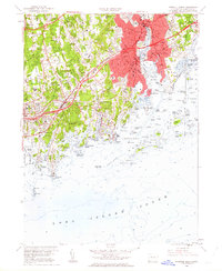
1960 Map of Norwalk South
USGS Topo · Published 1963About this map
Norwalk and the surrounding shoreline communities of Darien and Rowayton reveal a landscape defined by postwar suburban expansion and a deeply indented coast. The development of the Connecticut Turnpike and the Merritt Parkway signals the era's rapid transit growth, intersecting older rail lines like the New York New Haven and Hartford railroad. Inland, numerous educational and religious institutions such as Sacred Heart Academy, Talmadge Hill Chapel, and Ferndale Seminary are established among family-named burial grounds like Slawson Cem and Weed Cem. Along the Long Island Sound, a dense archipelago including Sheffield Island, Chimon Island, and Ram Island protects the approaches to Norwalk Harbor. This coastal network, marked by the Greens Ledge Lighthouse, illustrates the area's transition from maritime trade to a residential and recreational hub, evidenced by the several country clubs and yacht clubs dotting the waterfront.
Find a feature on this map
99 named features on this map. Tap any name to fly to it.
Don’t see what you’re looking for? This feature index may not catch every label — zoom into the map to look around manually.
Map Details
Editions of this 1960 Norwalk South Map
3 editions found
Other maps of this area

1892 · Stamford
USGS Topo · 1:62,500

1892 · Norwalk
USGS Topo · 1:62,500

1893 · Stamford
USGS Topo · 1:62,500

1893 · Norwalk
USGS Topo · 1:62,500

1897 · Oyster Bay
USGS Topo · 1:62,500

1898 · Oyster Bay
USGS Topo · 1:62,500

1899 · Stamford
USGS Topo · 1:62,500

1900 · Oyster Bay
USGS Topo · 1:62,500

1901 · Northport
USGS Topo · 1:62,500

1903 · Northport
USGS Topo · 1:62,500