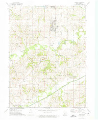
1972 Map of Norwalk
USGS Topo · Published 1975About this map
Norwalk and the developing suburbs south of Des Moines are captured during a period of steady growth in Warren County. The map shows the suburban expansion of Lakewood and the residential core of Norwalk, which is surrounded by the productive agricultural townships of Linn, Greenfield, Jefferson, and Lincoln. The landscape is defined by the winding courses of the North River and Middle River, where an Old River oxbow suggests a history of shifting water channels.
Find a feature on this map
59 named features on this map. Tap any name to fly to it.
Don’t see what you’re looking for? This feature index may not catch every label — zoom into the map to look around manually.
Map Details
Editions of this 1972 Norwalk Map
This is the sole edition of this map. No revisions or reprints were ever made.
Other maps of this area

1905 · Des Moines
USGS Topo · 1:62,500

1907 · Des Moines
USGS Topo · 1:62,500

1908 · Waukee
USGS Topo · 1:62,500

1931 · Indianola
USGS Topo · 1:62,500

1951 · St. Charles
USGS Topo · 1:62,500

1954 · Des Moines
USGS Topo · 1:250,000

1956 · Des Moines
USGS Topo · 1:250,000

1956 · Des Moines SW
USGS Topo · 1:24,000

1956 · Des Moines SE
USGS Topo · 1:24,000

1956 · Des Moines
USGS Topo · 1:62,500