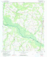
1979 Map of Norway West
USGS Topo · Published 1991About this map
The South Fork Edisto River carves a broad, swampy path through this landscape, marking the natural boundary between Orangeburg, Barnwell, and Bamberg counties. This low-country terrain is defined by its watercourses, from the meandering Little River and Willow Swamp to the smaller Goodland Creek and Rocky Swamp. The rail-centered town of Norway serves as the primary hub, situated along the Seaboard Coast Line tracks that also pass through the small settlement of Sweden to the south.
Find a feature on this map
33 named features on this map. Tap any name to fly to it.
Don’t see what you’re looking for? This feature index may not catch every label — zoom into the map to look around manually.
Map Details
Editions of this 1979 Norway West Map
This is the sole edition of this map. No revisions or reprints were ever made.
Other maps of this area

1919 · Bamberg
USGS Topo · 1:48,000

1920 · Bamberg
USGS Topo · 1:62,500

1923 · Williston
USGS Topo · 1:48,000

1927 · Williston
USGS Topo · 1:62,500

1943 · Bamberg
USGS Topo · 1:62,500

1943 · Williston
USGS Topo · 1:62,500

1944 · Seivern
USGS Topo · 1:62,500

1946 · Woodford
USGS Topo · 1:62,500

1954 · Augusta
USGS Topo · 1:250,000

1957 · Augusta
USGS Topo · 1:250,000