
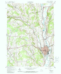
1943 Map of Norwich
USGS Topo · Published 1960About this map
The city of Norwich serves as the focal point of this 1940s survey, situated at the confluence of Canasawacta Creek and the Chenango River. The era's transportation infrastructure is clearly defined, with the New York Ontario and Western railroad corridor and an abandoned Canal following the river valley through North Norwich and Plasterville. The landscape transitions from the urban grid of the county seat to the uplands of Plymouth and Preston, where a network of numbered schools, such as School No 6 and School No 9, served scattered rural communities.
Find a feature on this map
53 named features on this map. Tap any name to fly to it.
Don’t see what you’re looking for? This feature index may not catch every label — zoom into the map to look around manually.
Map Details
Editions of this 1943 Norwich Map
2 editions found
Other maps of this area

1902 · Coventry
USGS Topo · 1:62,500

1903 · Norwich
USGS Topo · 1:62,500

1904 · Oxford
USGS Topo · 1:62,500

1910 · New Berlin
USGS Topo · 1:62,500

1912 · New Berlin
USGS Topo · 1:62,500

1915 · Unadilla
USGS Topo · 1:62,500

1918 · Unadilla
USGS Topo · 1:62,500

1943 · Otselic
USGS Topo · 1:24,000

1943 · Holmesville
USGS Topo · 1:24,000
1943 · Guilford
USGS Topo · 1:24,000