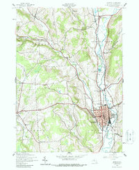
1943 Map of Norwich
USGS Topo · Published 1988About this map
The Chenango River valley serves as the central artery for this mid-century landscape, dominated by the concentrated grid of Norwich and the parallel rail lines that define its industrial geography. The New York Ontario and Western and the Delaware Lackawanna and Western railroads track the riverbanks, supporting a network of small settlements like North Norwich and South Plymouth. Beyond the valley floor, the terrain rises into the steep ridges of Tinker Ridge and the German Hollow area.
Find a feature on this map
50 named features on this map. Tap any name to fly to it.
Don’t see what you’re looking for? This feature index may not catch every label — zoom into the map to look around manually.
Map Details
Editions of this 1943 Norwich Map
2 editions found
Other maps of this area

1902 · Coventry
USGS Topo · 1:62,500

1903 · Norwich
USGS Topo · 1:62,500

1904 · Oxford
USGS Topo · 1:62,500

1910 · New Berlin
USGS Topo · 1:62,500

1912 · New Berlin
USGS Topo · 1:62,500

1915 · Unadilla
USGS Topo · 1:62,500

1918 · Unadilla
USGS Topo · 1:62,500

1943 · Otselic
USGS Topo · 1:24,000

1943 · Holmesville
USGS Topo · 1:24,000

1943 · Norwich
USGS Topo · 1:24,000