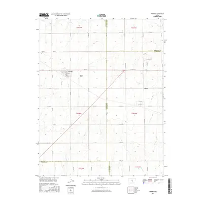
2015 Map of Norwich
USGS Topo · Published 2015About this map
Norwich and Milton anchor this central Kansas landscape where Kingman, Sedgwick, Sumner, and Harper counties converge. The terrain is defined by a grid of agricultural section lines and several drainage systems, including Sand Cr and Sandy Cr which flow toward the south and east. This 2015 study illustrates the precise intersections of the county lines, particularly where the Kingman Co Sumner Co boundary meets the northern edge of Harper Co. Local history is preserved in several rural burial grounds such as Upchurch Cem near the northwestern corner and Stitch Cem further south. The presence of the Norwich Airport just east of its namesake town indicates the ongoing importance of local aviation in this rural region. The map also records the exact placement of residential streets like Briarwood and Parkway St in the heart of Norwich.
Find a feature on this map
66 named features on this map. Tap any name to fly to it.
Don’t see what you’re looking for? This feature index may not catch every label — zoom into the map to look around manually.
Map Details
Editions of this 2015 Norwich Map
This is the sole edition of this map. No revisions or reprints were ever made.
Other maps of this area

1889 · Cheney
USGS Topo · 1:125,000

1889 · Caldwell
USGS Topo · 1:125,000

1891 · Cheney
USGS Topo · 1:125,000

1893 · Caldwell
USGS Topo · 1:125,000

1897 · Caldwell
USGS Topo · 1:125,000

1901 · Cheney
USGS Topo · 1:125,000

1955 · Wichita
USGS Topo · 1:250,000

1958 · Wichita
USGS Topo · 1:250,000

1965 · Cheney SE
USGS Topo · 1:24,000
1965 · Lake Afton
USGS Topo · 1:24,000