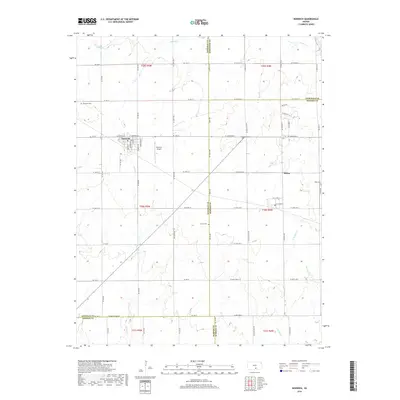
2018 Map of Norwich
USGS Topo · Published 2018About this map
Norwich and the surrounding agricultural landscape are documented here at a point where the boundaries of four Kansas counties — Kingman, Sedgwick, Sumner, and Harper — converge. The survey illustrates a highly regular section-line road network, typical of the Great Plains, punctuated by small rural settlements and essential local landmarks. To the east, the community of Milton sits near the headwaters of N Br State Cr, while the western portion of the map is defined by the winding course of Sandy Cr.
Find a feature on this map
69 named features on this map. Tap any name to fly to it.
Don’t see what you’re looking for? This feature index may not catch every label — zoom into the map to look around manually.
Map Details
Editions of this 2018 Norwich Map
This is the sole edition of this map. No revisions or reprints were ever made.
Other maps of this area

1889 · Cheney
USGS Topo · 1:125,000

1889 · Caldwell
USGS Topo · 1:125,000

1891 · Cheney
USGS Topo · 1:125,000

1893 · Caldwell
USGS Topo · 1:125,000

1897 · Caldwell
USGS Topo · 1:125,000

1901 · Cheney
USGS Topo · 1:125,000

1955 · Wichita
USGS Topo · 1:250,000

1958 · Wichita
USGS Topo · 1:250,000

1965 · Cheney SE
USGS Topo · 1:24,000
1965 · Lake Afton
USGS Topo · 1:24,000