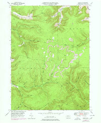
1948 Map of Norwich
USGS Topo · Published 1978About this map
Norwich sits at the western edge of this 1948 survey, located at the confluence where several hollows meet the winding Potato Creek. The landscape of this McKean County township is defined by its industrial utility and deep drainage patterns, featuring the Havens Pipeline and another prominent Pipe Line cutting through the forested high ground. These industrial markers run alongside a dense network of watercourses and named hollows, such as Combs Creek and McAllister Hol, which carve through the high terrain of Dividing Ridge.
Find a feature on this map
41 named features on this map. Tap any name to fly to it.
Don’t see what you’re looking for? This feature index may not catch every label — zoom into the map to look around manually.
Map Details
Editions of this 1948 Norwich Map
4 editions found

Other maps of this area

1933 · Smethport
USGS Topo · 1:62,500

1934 · Coudersport
USGS Topo · 1:48,000

1937 · Smethport
USGS Topo · 1:62,500

1938 · Coudersport
USGS Topo · 1:62,500

1948 · Crosby
USGS Topo · 1:62,500

1948 · Emporium
USGS Topo · 1:62,500

1948 · Keating Summit
USGS Topo · 1:24,000

1948 · Emporium
USGS Topo · 1:24,000

1948 · Wildwood Fire Tower
USGS Topo · 1:24,000

1948 · Rich Valley
USGS Topo · 1:24,000