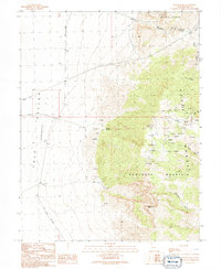
1991 Map of Notch Peak
USGS Topo · Published 1991About this map
Sawtooth Mountain and the towering height of Notch Peak dominate this landscape, where the high-altitude terrain of the House Range meets the vast basin of the Tule Valley (Depression). The map reveals a history of remote human activity through scattered resource extraction and isolated dwellings, most notably The Hermits Cabin located near the northern reaches of the quadrangle. Prospecting was clearly a primary driver of movement here, evidenced by numerous prospects and the Brown Queen Mine etched into the canyons.
Find a feature on this map
27 named features on this map. Tap any name to fly to it.
Don’t see what you’re looking for? This feature index may not catch every label — zoom into the map to look around manually.
Map Details
Editions of this 1991 Notch Peak Map
This is the sole edition of this map. No revisions or reprints were ever made.
Other maps of this area

1908 · Fish Springs
USGS Topo · 1:250,000

1910 · Fish Springs
USGS Topo · 1:250,000

1953 · Delta
USGS Topo · 1:250,000

1958 · Delta
USGS Topo · 1:250,000

1959 · Cowboy Pass
USGS Topo · 1:62,500

1960 · Notch Peak
USGS Topo · 1:62,500

1960 · Conger Mountain
USGS Topo · 1:62,500

1962 · Delta
USGS Topo · 1:250,000

1972 · Swasey Peak SW
USGS Topo · 1:24,000
1972 · Marjum Pass
USGS Topo · 1:24,000