
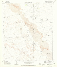
1971 Map of Notrees NW
USGS Topo · Published 1974About this map
Kermit Sand Hills dominate this portion of Winkler County, where the landscape is defined by extensive tracts of Shifting Sand. The 1971 survey reveals an environment shaped heavily by the extraction industry, marked by a dense network of infrastructure including the Keystone Se Oil Field and the Circle Oil Field. Numerous instances of Oil Well and Drill Hole locations are scattered throughout the dunes, connected by an intricate system of Pipeline and Aqueduct routes. Beyond the industrial footprint, human presence is noted at the Roadside Park and along various Jeep Trail paths that navigate the difficult terrain. Local landmarks such as the North Windmill and a Radio Tower provide essential orientation points in a largely unsettled area where water sources like Wells were critical for sustaining operations.
Find a feature on this map
17 named features on this map. Tap any name to fly to it.
Don’t see what you’re looking for? This feature index may not catch every label — zoom into the map to look around manually.
Map Details
Editions of this 1971 Notrees NW Map
This is the sole edition of this map. No revisions or reprints were ever made.
Other maps of this area

1954 · Hobbs
USGS Topo · 1:250,000

1954 · Pecos
USGS Topo · 1:250,000

1957 · Pecos
USGS Topo · 1:250,000

1958 · Hobbs
USGS Topo · 1:250,000

1969 · Jal SE
USGS Topo · 1:24,000

1970 · Vesrue
USGS Topo · 1:24,000

1970 · Kermit
USGS Topo · 1:24,000

1971 · Notrees
USGS Topo · 1:24,000

1971 · Bedford Ranch
USGS Topo · 1:24,000
1971 · Amburgey Ranch
USGS Topo · 1:24,000