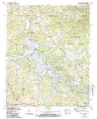
1988 Map of Nottely Dam
USGS Topo · Published 1988About this map
Nottely Lake dominates this north Georgia landscape, its irregular shoreline reaching into the valleys of Ivylog Creek and Conley Creek. In the late 1980s, the area remained deeply influenced by the Tennessee Valley Authority’s Nottely Dam project, which transformed the Nottely River into a complex reservoir. The terrain is defined by significant elevations like Clink Webster Mountain and Moccasin Mountain, with the boundary between the Chattahoochee National Forest and Nantahala National Forest marking the state line between Georgia and North Carolina.
Find a feature on this map
85 named features on this map. Tap any name to fly to it.
Don’t see what you’re looking for? This feature index may not catch every label — zoom into the map to look around manually.
Map Details
Editions of this 1988 Nottely Dam Map
2 editions found
Other maps of this area

1886 · Dahlonega
USGS Topo · 1:125,000

1888 · Ellijay
USGS Topo · 1:125,000

1892 · Dahlonega
USGS Topo · 1:125,000

1892 · Ellijay
USGS Topo · 1:125,000

1893 · Murphy
USGS Topo · 1:125,000

1896 · Dahlonega
USGS Topo · 1:125,000

1898 · Ellijay
USGS Topo · 1:125,000

1903 · Dahlonega
USGS Topo · 1:125,000

1911 · Ellijay
USGS Topo · 1:125,000

1914 · Murphy
USGS Topo · 1:125,000