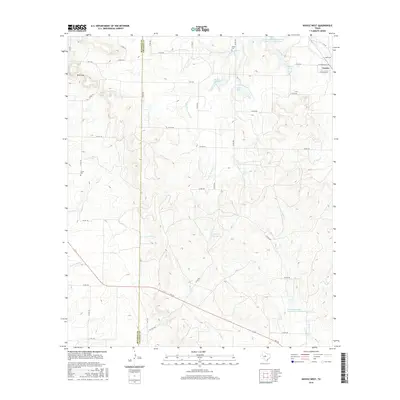
2016 Map of Novice West
USGS Topo · Published 2016About this map
The boundary between Runnels Co and Coleman Co bisects this West Texas landscape, where the small community of Novice sits in the northeast corner. This 2016 survey highlights a region defined by complex drainage systems and water management, featuring numerous named reservoirs such as Novice City Lake, Daniels Lake, and Coker Lake. The terrain is punctuated by significant natural features like Blue Gap and several perennial water sources including Willow Spring, Jim Ned Spring, and Pecan Spring. For genealogists and local historians, the map preserves the location of Atoka Cem and Crews Cem, providing specific spatial context for early settlements. The topography is intricately carved by several major creek forks, notably the S Fork Jim Ned Cr, Hords Cr, and S Fork Mud Cr, which dictated the layout of the rural road network and FM routes.
Find a feature on this map
51 named features on this map. Tap any name to fly to it.
Don’t see what you’re looking for? This feature index may not catch every label — zoom into the map to look around manually.
Map Details
Editions of this 2016 Novice West Map
This is the sole edition of this map. No revisions or reprints were ever made.
Other maps of this area

1890 · Abilene
USGS Topo · 1:125,000

1892 · Abilene
USGS Topo · 1:125,000

1892 · Ballinger
USGS Topo · 1:125,000

1954 · Brownwood
USGS Topo · 1:250,000

1954 · Abilene
USGS Topo · 1:250,000

1958 · Abilene
USGS Topo · 1:250,000

1967 · Talpa
USGS Topo · 1:24,000

1967 · Novice West
USGS Topo · 1:24,000
1967 · Novice East
USGS Topo · 1:24,000
1967 · Valera
USGS Topo · 1:24,000