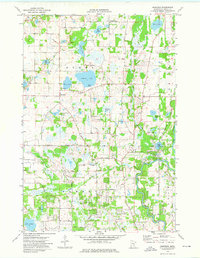
1974 Map of Nowthen
USGS Topo · Published 1976About this map
The Rum River winds through the eastern edge of this landscape, a region defined by its numerous glacial basins and early rural infrastructure. In the town of Nowthen, the Townhall and Lakeview Cem sit near the shores of Bass Lake and Pickerel Lake, illustrating the tight-knit settlement patterns of central Anoka County. The area south of Burns transitions into Ramsey, where the drainage network is supplemented by Ditch No 14 and Ditch No 51, reflecting efforts to manage the wetlands surrounding Trott Brook. Local transportation and community hubs are well-documented, from Mitchell Corners in the north to the Faherty Bridge crossing. Genealogists will find particular value in the locations of Trott Brook Ch and its namesake Trott Brook Cem, alongside newer additions like the Lord of Life Ch.
Find a feature on this map
46 named features on this map. Tap any name to fly to it.
Don’t see what you’re looking for? This feature index may not catch every label — zoom into the map to look around manually.
Map Details
Editions of this 1974 Nowthen Map
2 editions found
Other maps of this area

1902 · Anoka
USGS Topo · 1:62,500

1909 · Rockford
USGS Topo · 1:62,500

1916 · St. Francis
USGS Topo · 1:62,500

1919 · St. Francis
USGS Topo · 1:62,500

1953 · Stillwater
USGS Topo · 1:250,000

1955 · Anoka
USGS Topo · 1:24,000

1955 · Coon Rapids
USGS Topo · 1:24,000

1955 · Anoka
USGS Topo · 1:62,500

1955 · Stillwater
USGS Topo · 1:250,000

1958 · Stillwater
USGS Topo · 1:250,000