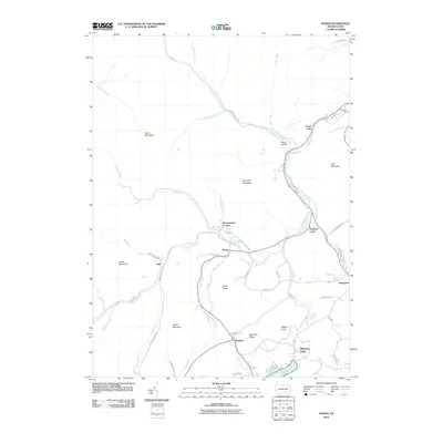
2010 Map of Noxen
USGS Topo · Published 2010About this map
Bowman Creek carves a deep valley through the Wyoming Valley highlands, serving as the primary corridor for settlement and transit between Stone Mountain and Schooley Mountain. Near the center of the quadrangle, the community of Noxen sits at the confluence of Beaver Run and the creek, once a busy junction for local transport. To the south, the northern reaches of Harveys Lake appear, a significant landmark in Luzerne County's landscape. The map reveals a network of ridges such as Grassy Ridge and Beechnut Ridge that separate the smaller hamlets of Ruggles and Beaumont. Higher elevations are defined by prominent peaks like South Mountain and Hickory Knob, while deep drainages like Roote Hollow and Broad Hollow Run emphasize the area's complex hydrography. The distribution of family-named roads and remote corners like Stull and Hettesheimer Corners reflects a long history of rural settlement tied to the region's timber and water resources.
Find a feature on this map
59 named features on this map. Tap any name to fly to it.
Don’t see what you’re looking for? This feature index may not catch every label — zoom into the map to look around manually.
Map Details
Editions of this 2010 Noxen Map
This is the sole edition of this map. No revisions or reprints were ever made.
Other maps of this area

1891 · Harveys Lake
USGS Topo · 1:62,500

1893 · Harvey Lake
USGS Topo · 1:62,500

1893 · Pittston
USGS Topo · 1:62,500

1943 · Scranton
USGS Topo · 1:125,000

1945 · Meshoppen
USGS Topo · 1:62,500

1945 · Jenningsville
USGS Topo · 1:24,000

1945 · Meshoppen
USGS Topo · 1:24,000

1946 · Tunkhannock
USGS Topo · 1:62,500

1946 · Kingston
USGS Topo · 1:24,000

1946 · Dutch Mtn
USGS Topo · 1:24,000
Featured Places
- Dallas Township, PA
- Harveys Lake, PA
- Noxen Township, PA
- Forkston Township, PA
- Evans Falls, Monroe Township