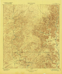
1896 Map of Nueces
USGS Topo · Published 1921About this map
Nueces River canyon systems and upland plateaus dominate this landscape as it appeared in the late nineteenth century. The area is defined by a remote network of springs and family ranches, where water sources like Kickapoo Spring, Justice Spring, and the Black Water Hole served as vital anchors for early settlement. Larger operations including the Ford and Holliday Ranch and Burr and Allen Ranch were scattered across the high country, connected by a rudimentary Trail network. Small communities such as Barksdale, Montell, and Vance cluster near the riverbanks and mountain foothills. The topography is meticulously detailed, showing prominent landmarks like Bullhead Mt and Military Mt that guided travelers before modern roads. This 1891–92 survey captures the transition from a rugged frontier to a structured ranching economy in the Edwards Plateau region.
Find a feature on this map
68 named features on this map. Tap any name to fly to it.
Don’t see what you’re looking for? This feature index may not catch every label — zoom into the map to look around manually.
Map Details
Editions of this 1896 Nueces Map
4 editions found
Other maps of this area

1893 · Rock Springs
USGS Topo · 1:125,000

1893 · Nueces
USGS Topo · 1:125,000

1896 · Nueces
USGS Topo · 1:125,000

1896 · Brackett
USGS Topo · 1:125,000

1897 · Brackett
USGS Topo · 1:125,000

1898 · Uvalde
USGS Topo · 1:125,000

1899 · Uvalde
USGS Topo · 1:125,000

1938 · Turkey Mountain
USGS Topo · 1:48,000

1941 · Standart
USGS Topo · 1:62,500

1943 · Turkey Mountain
USGS Topo · 1:62,500