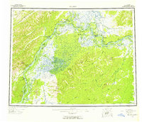
1952 Map of Nulato
USGS Topo · Published 1958About this map
The Yukon River and Koyukuk River dominate this mid-century interior landscape, serving as the primary arteries for travel and settlement in the Fourth Judicial Division. The confluence of these major waterways defines the regional geography, where the village of Nulato sits across from Nulato Island. To the east, the village of Galena and the Galena Air Force Base represent the strategic military and transportation infrastructure established during and after the war.
Find a feature on this map
80 named features on this map. Tap any name to fly to it.
Don’t see what you’re looking for? This feature index may not catch every label — zoom into the map to look around manually.
Map Details
Editions of this 1952 Nulato Map
4 editions found

Other maps of this area

1945 · Nulato
USGS Topo · 1:250,000

1948 · Norton Bay
USGS Topo · 1:250,000

1950 · Medfra
USGS Topo · 1:250,000

1951 · Candle
USGS Topo · 1:250,000

1951 · Ophir
USGS Topo · 1:250,000

1951 · Nulato
USGS Topo · 1:250,000

1951 · Unalakleet
USGS Topo · 1:250,000

1951 · Ruby
USGS Topo · 1:250,000

1951 · Norton Bay
USGS Topo · 1:250,000

1951 · Kateel River
USGS Topo · 1:250,000