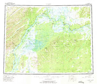
1952 Map of Nulato
USGS Topo · Published 1975About this map
The Yukon River serves as the central artery for this interior Alaskan region, anchored by the river settlements of Nulato, Kaltag, and Galena. This 1952 survey documents a landscape defined by seasonal movement and cold-war infrastructure, most notably the Galena Air Force Base and the Kaltag CAA Station. These outposts represent the era's focus on arctic aviation and communications, while an Abandoned Telegraph Line tracing the northern bank marks an earlier phase of terrestrial connectivity.
Find a feature on this map
56 named features on this map. Tap any name to fly to it.
Don’t see what you’re looking for? This feature index may not catch every label — zoom into the map to look around manually.
Map Details
Editions of this 1952 Nulato Map
4 editions found

Other maps of this area

1945 · Nulato
USGS Topo · 1:250,000

1948 · Norton Bay
USGS Topo · 1:250,000

1950 · Medfra
USGS Topo · 1:250,000

1951 · Candle
USGS Topo · 1:250,000

1951 · Ophir
USGS Topo · 1:250,000

1951 · Nulato
USGS Topo · 1:250,000

1951 · Unalakleet
USGS Topo · 1:250,000

1951 · Ruby
USGS Topo · 1:250,000

1951 · Norton Bay
USGS Topo · 1:250,000

1951 · Kateel River
USGS Topo · 1:250,000