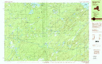
1989 Map of Number Four
USGS Topo · Published 1989About this map
Adirondack Park dominates this landscape, where the sprawling forest is punctuated by a dense network of glacial lakes and rushing waterways. The settlement of Number Four stands as the primary human landmark amidst a wilderness defined by landmarks like Stillwater Mountain and Mount Tom. The hydraulic character of the region is mapped in detail, from the expanse of the Stillwater Reservoir to the cascades at Moshier Falls.
Find a feature on this map
56 named features on this map. Tap any name to fly to it.
Don’t see what you’re looking for? This feature index may not catch every label — zoom into the map to look around manually.
Map Details
Editions of this 1989 Number Four Map
2 editions found
Other maps of this area

1901 · Old Forge
USGS Topo · 1:62,500

1903 · Big Moose
USGS Topo · 1:62,500

1905 · Port Leyden
USGS Topo · 1:62,500

1907 · Port Leyden
USGS Topo · 1:62,500

1911 · Lowville
USGS Topo · 1:62,500

1912 · Number Four
USGS Topo · 1:62,500

1912 · Mc Keever
USGS Topo · 1:62,500

1913 · Lowville
USGS Topo · 1:62,500

1915 · Number Four
USGS Topo · 1:62,500

1940 · Port Leyden
USGS Topo · 1:62,500