
2023 Map of Nunda
USGS Topo · Published 2023About this map
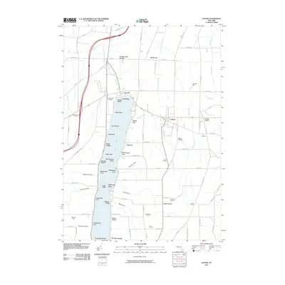
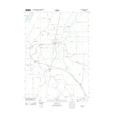
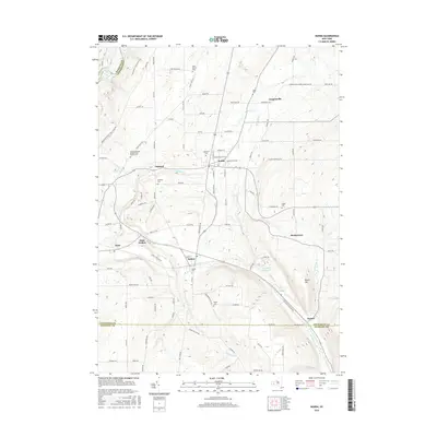
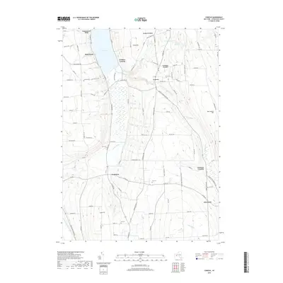
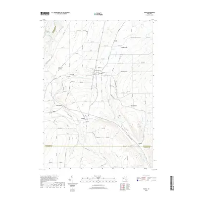
Keshequa Creek carves a significant path through this part of Livingston County, defining the valley where Nunda, Oakland, and Dalton were established. The landscape is marked by numerous family and community burial grounds that reflect the area's long settlement history, including the Colonel George Williams And Family Cem and the Saint Helena Cem near the Genesee River. The terrain rises from the creek valleys toward elevations like Round Top, with the Nunda Reservoir tucked into the hills south of Barkertown. The road network, including the Mount Morris Nunda Rd and Picket Line RD, connects these small hamlets across the rolling topography of the Nunda quadrangle. This layout reveals a traditional New York agricultural and small-town structure that has persisted into the modern era.
Find a feature on this map
116 named features on this map. Tap any name to fly to it.
Don’t see what you’re looking for? This feature index may not catch every label — zoom into the map to look around manually.
Map Details
Editions of this 2023 Nunda Map
This is the sole edition of this map. No revisions or reprints were ever made.
Historical Maps of Mount Morris Through Time
81 maps found

1902 Wayland
Livingston County, NY

1904 Caledonia
Livingston County, NY

1904 Wayland
Livingston County, NY

1905 Nunda
Livingston County, NY

1934 Rush
Livingston County, NY

1942 Conesus
Livingston County, NY

1942 Livonia
Livingston County, NY

1943 Mount Morris
Livingston County, NY

1943 Nunda
Livingston County, NY

1943 Ossian
Livingston County, NY

1943 Sonyea
Livingston County, NY

1944 Geneseo
Livingston County, NY

1944 Leicester
Livingston County, NY

1944 Mount Morris
Livingston County, NY

1944 Nunda
Livingston County, NY

1944 Ossian
Livingston County, NY

1944 Sonyea
Livingston County, NY

1950 Caledonia
Livingston County, NY

1950 Geneseo
Livingston County, NY

1951 Caledonia
Livingston County, NY

1951 Leicester
Livingston County, NY

1951 Livonia
Livingston County, NY

1951 Rush
Livingston County, NY

1957 Conesus
Livingston County, NY

1964 Conesus
Livingston County, NY

1971 Rush
Livingston County, NY

1972 Mount Morris
Livingston County, NY

1972 Nunda
Livingston County, NY

1972 Ossian
Livingston County, NY

1972 Sonyea
Livingston County, NY

1983 Canandaigua
Livingston County, NY

2010 Caledonia
Livingston County, NY

2010 Conesus
Livingston County, NY

2010 Geneseo
Livingston County, NY

2010 Leicester
Livingston County, NY
2010 Livonia
Livingston County, NY

2010 Mount Morris
Livingston County, NY
2010 Nunda
Livingston County, NY

2010 Ossian
Livingston County, NY

2010 Rush
Livingston County, NY

2010 Sonyea
Livingston County, NY

2013 Caledonia
Livingston County, NY
2013 Conesus
Livingston County, NY

2013 Geneseo
Livingston County, NY

2013 Leicester
Livingston County, NY
2013 Livonia
Livingston County, NY

2013 Mount Morris
Livingston County, NY
2013 Nunda
Livingston County, NY

2013 Ossian
Livingston County, NY

2013 Rush
Livingston County, NY

2013 Sonyea
Livingston County, NY

2016 Caledonia
Livingston County, NY
2016 Conesus
Livingston County, NY

2016 Geneseo
Livingston County, NY
2016 Leicester
Livingston County, NY
2016 Livonia
Livingston County, NY

2016 Mount Morris
Livingston County, NY
2016 Nunda
Livingston County, NY
2016 Ossian
Livingston County, NY
2016 Rush
Livingston County, NY

2016 Sonyea
Livingston County, NY
2019 Caledonia
Livingston County, NY
2019 Conesus
Livingston County, NY
2019 Geneseo
Livingston County, NY
2019 Leicester
Livingston County, NY
2019 Livonia
Livingston County, NY

2019 Mount Morris
Livingston County, NY
2019 Nunda
Livingston County, NY
2019 Ossian
Livingston County, NY
2019 Rush
Livingston County, NY

2019 Sonyea
Livingston County, NY

2023 Caledonia
Livingston County, NY

2023 Conesus
Livingston County, NY

2023 Geneseo
Livingston County, NY

2023 Leicester
Livingston County, NY

2023 Livonia
Livingston County, NY

2023 Mount Morris
Livingston County, NY
2023 Nunda
Livingston County, NY

2023 Ossian
Livingston County, NY

2023 Rush
Livingston County, NY

2023 Sonyea
Livingston County, NY