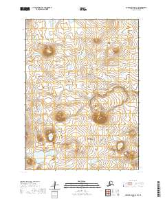
2020 Map of Nunivak Island A-3 SW
USGS Topo · Published 2020About this map
Nanwaksjiak Crater dominates the volcanic landscape of this southwestern portion of Nunivak Island. This 2020 topographic record provides a clear look at the dramatic depressions and elevation contours of the Bering Sea island's interior. The terrain is characterized by numerous small lakes and ponds scattered across the tundra between the high rims of the crater and surrounding peaks. Primarily consisting of public lands within the t1s r98w, t1s r97w, t2s r98w, and t2s r97w survey blocks, the map details a remote environment defined by its unique geological formations rather than human settlement. The absence of roads or structures emphasizes the isolation of this part of the Bethel Census Area.
Find a feature on this map
5 named features on this map. Tap any name to fly to it.
Don’t see what you’re looking for? This feature index may not catch every label — zoom into the map to look around manually.
Map Details
Editions of this 2020 Nunivak Island A-3 SW Map
This is the sole edition of this map. No revisions or reprints were ever made.
Other maps of this area

1951 · Cape Mendenhall
USGS Topo · 1:250,000

1951 · Nunivak Island
USGS Topo · 1:250,000

1952 · Cape Mendenhall D-4
USGS Topo · 1:63,360

1952 · Cape Mendenhall D-3
USGS Topo · 1:63,360

1952 · Nunivak Island A-4
USGS Topo · 1:63,360

1952 · Cape Mendenhall
USGS Topo · 1:250,000

1952 · Nunivak Island A-3
USGS Topo · 1:63,360

1954 · Nunivak Island
USGS Topo · 1:250,000

1958 · Nunivak Island
USGS Topo · 1:250,000

1964 · Nunivak Island
USGS Topo · 1:250,000