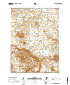
2020 Map of Nunivak Island A-4 SE
USGS Topo · Published 2020About this map
Mt Roberts rises as a prominent landmark on the volcanic landscape of Nunivak Island, anchoring the southern portion of this interior terrain. The area is defined by its dramatic geological formations, most notably the Binalik Crater, which sits adjacent to Ahkiwiksnuk Lake. This map details the unpopulated tundra and drainage patterns within the Bethel Census Area, illustrating how water collects in scattered pools across the undulating surface. The layout of section lines and townships, including t1s r99w and t2s r98w, provides the primary structural grid for this remote maritime environment, where the land is shaped by ancient volcanic activity and modern permafrost processes.
Find a feature on this map
8 named features on this map. Tap any name to fly to it.
Don’t see what you’re looking for? This feature index may not catch every label — zoom into the map to look around manually.
Map Details
Editions of this 2020 Nunivak Island A-4 SE Map
This is the sole edition of this map. No revisions or reprints were ever made.
Other maps of this area

1951 · Cape Mendenhall
USGS Topo · 1:250,000

1951 · Nunivak Island
USGS Topo · 1:250,000

1952 · Cape Mendenhall D-4
USGS Topo · 1:63,360

1952 · Cape Mendenhall D-3
USGS Topo · 1:63,360

1952 · Nunivak Island A-4
USGS Topo · 1:63,360

1952 · Cape Mendenhall
USGS Topo · 1:250,000

1952 · Nunivak Island A-3
USGS Topo · 1:63,360

1954 · Nunivak Island
USGS Topo · 1:250,000

1958 · Nunivak Island
USGS Topo · 1:250,000

1964 · Nunivak Island
USGS Topo · 1:250,000