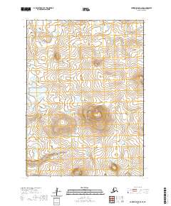
2020 Map of Nunivak Island A-5 SE
USGS Topo · Published 2020About this map
Nunivak Island is the centerpiece of this topographic study, showcasing a remote and largely untouched Alaskan landscape. The terrain is defined by the prominent peak of Indooli Mtn, which rises above a network of tundra waterways and drainage systems. Water movement across the island is dictated by the Ahding River in the north and the Chakwakamiut River further south. These river systems reflect a classic Bering Sea island hydrology, where low-lying drainage basins connect smaller ponds and wetland features between higher volcanic ridges. The absence of modern infrastructure or permanent settlements within these particular township boundaries emphasizes the wilderness character of the island, which serves as a critical habitat within the Bethel Census Area.
Find a feature on this map
8 named features on this map. Tap any name to fly to it.
Don’t see what you’re looking for? This feature index may not catch every label — zoom into the map to look around manually.
Map Details
Editions of this 2020 Nunivak Island A-5 SE Map
This is the sole edition of this map. No revisions or reprints were ever made.
Other maps of this area

1951 · Cape Mendenhall
USGS Topo · 1:250,000

1951 · Nunivak Island
USGS Topo · 1:250,000

1952 · Cape Mendenhall D-4
USGS Topo · 1:63,360

1952 · Nunivak Island A-4
USGS Topo · 1:63,360

1952 · Cape Mendenhall
USGS Topo · 1:250,000

1952 · Nunivak Island A-5
USGS Topo · 1:63,360
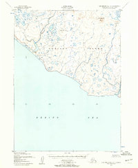
1952 · Cape Mendenhall D-5
USGS Topo · 1:63,360

1954 · Nunivak Island
USGS Topo · 1:250,000

1958 · Nunivak Island
USGS Topo · 1:250,000

1964 · Nunivak Island
USGS Topo · 1:250,000