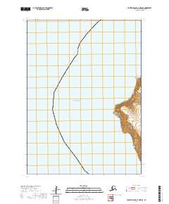
2020 Map of Nunivak Island C-1 OE W SE
USGS Topo · Published 2020About this map
Cape Vancouver anchors the eastern coastline of this map, where the coastal terrain of the Bethel Census Area meets the expansive Bering Sea. The map captures a rugged coastal profile defined by high relief near Talurarevuk Point and the waters of Etolin Strait, which separates this region from the mainland. This 2020 edition provides a clear record of the shoreline before modern environmental shifts significantly alter these high-latitude landforms. The landscape is primarily maritime and uninhabited, dominated by the natural contours of the coast and the surveying boundaries of t6n r92w and t5n r92w.
Find a feature on this map
6 named features on this map. Tap any name to fly to it.
Don’t see what you’re looking for? This feature index may not catch every label — zoom into the map to look around manually.
Map Details
Editions of this 2020 Nunivak Island C-1 OE W SE Map
This is the sole edition of this map. No revisions or reprints were ever made.
Other maps of this area

1951 · Nunivak Island
USGS Topo · 1:250,000
1952 · Nunivak Island B-2
USGS Topo · 1:63,360

1954 · Nunivak Island
USGS Topo · 1:250,000

1954 · Nunivak Island B-1
USGS Topo · 1:63,360

1954 · Nunivak Island C-1
USGS Topo · 1:63,360

1958 · Nunivak Island
USGS Topo · 1:250,000

1964 · Nunivak Island
USGS Topo · 1:250,000
2020 · Nunivak Island B-1 NW
USGS Topo · 1:25,000
2020 · Nunivak Island C-1 SW
USGS Topo · 1:25,000