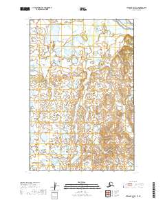
2019 Map of Nushagak Bay D-1 SE
USGS Topo · Published 2019About this map
The Pacific Ocean dominates the northern corner of this landscape, representing a remote stretch of the Alaska coastline where the sea meets a vast system of coastal wetlands and low-lying drainages. This 2019 survey documents a terrain defined by water, where the southern reaches are marked by the winding path of Clark Slough. The intricate network of small, unnamed ponds and seasonal water bodies illustrates the saturated nature of the Dillingham Census Area, highlighting a landscape that remains largely untouched by permanent road infrastructure or concentrated settlement. The Public Land Survey System grid, including boundaries for t15s r53w and t16s r53w, provides the primary framework for locating specific points across this coastal tundra.
Find a feature on this map
6 named features on this map. Tap any name to fly to it.
Don’t see what you’re looking for? This feature index may not catch every label — zoom into the map to look around manually.
Map Details
Editions of this 2019 Nushagak Bay D-1 SE Map
This is the sole edition of this map. No revisions or reprints were ever made.
Other maps of this area

1945 · Nushagak Bay
USGS Topo · 1:250,000

1949 · Nushagak Bay
USGS Topo · 1:250,000

1951 · Nushagak Bay
USGS Topo · 1:250,000

1952 · Naknek
USGS Topo · 1:250,000
1952 · Nushagak Bay C-1
USGS Topo · 1:63,360

1952 · Naknek C-6
USGS Topo · 1:63,360

1952 · Nushagak Bay D-1
USGS Topo · 1:63,360

1952 · Naknek D-6
USGS Topo · 1:63,360

1964 · Nushagak Bay
USGS Topo · 1:250,000

1964 · Naknek
USGS Topo · 1:250,000