
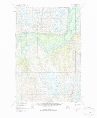
1952 Map of Naknek D-6
USGS Topo · Published 1963About this map
The Nushagak River dominates this mid-century landscape, carving a complex network of channels and braids through the Alaskan wilderness near Dillingham. Its shifting course is evidenced by the prominent Scandinavian Slough and the winding Keefer Cutoff, which isolate numerous low-lying islands. These waterways provided the primary transport corridors for the region, supplemented by a seasonal Winter Trail that cuts across the tundra to the north.
Find a feature on this map
7 named features on this map. Tap any name to fly to it.
Don’t see what you’re looking for? This feature index may not catch every label — zoom into the map to look around manually.
Map Details
Editions of this 1952 Naknek D-6 Map
2 editions found
Other maps of this area

1945 · Nushagak Bay
USGS Topo · 1:250,000

1949 · Nushagak Bay
USGS Topo · 1:250,000

1951 · Dillingham
USGS Topo · 1:250,000

1951 · Nushagak Bay
USGS Topo · 1:250,000

1952 · Naknek
USGS Topo · 1:250,000

1952 · Dillingham A-5
USGS Topo · 1:63,360

1952 · Naknek C-5
USGS Topo · 1:63,360
1952 · Nushagak Bay C-1
USGS Topo · 1:63,360

1952 · Naknek C-6
USGS Topo · 1:63,360

1952 · Naknek D-5
USGS Topo · 1:63,360