
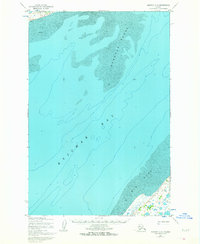
1952 Map of Naknek C-5
USGS Topo · Published 1958About this map
Kvichak Bay dominates this coastal survey, where the dynamic maritime environment of Bristol Bay is recorded through mid-century hydrographic data. Compiled from 1950 and 1951 source material, the map captures a landscape defined by expansive tidal features including the shifting Deadman Sands and the broad expanse of Big Flat. These sand and mud formations reveal the complex bathymetry of the northern bay, marked by intricate depth curves and soundings that were critical for navigation during the height of the region's salmon fishing era. Inland, a lone cabin and the Winter Trail represent the sparse but essential human infrastructure on the Alaskan coast. Near the shoreline, a feature labeled Bear sits along the trail, reflecting the remote nature of the terrain. The work of the Army Map Service and the Geological Survey is evident in the precise topographic contours and photogrammetric details of the coastal bluffs.
Find a feature on this map
9 named features on this map. Tap any name to fly to it.
Don’t see what you’re looking for? This feature index may not catch every label — zoom into the map to look around manually.
Map Details
Editions of this 1952 Naknek C-5 Map
2 editions found
Other maps of this area

1952 · Naknek
USGS Topo · 1:250,000

1952 · Naknek B-4
USGS Topo · 1:63,360

1952 · Naknek B-5
USGS Topo · 1:63,360

1952 · Naknek C-6
USGS Topo · 1:63,360

1952 · Naknek D-5
USGS Topo · 1:63,360

1952 · Naknek D-4
USGS Topo · 1:63,360

1952 · Naknek D-6
USGS Topo · 1:63,360

1952 · Naknek C-4
USGS Topo · 1:63,360

1964 · Naknek
USGS Topo · 1:250,000
2019 · Naknek B-4 NW
USGS Topo · 1:25,000