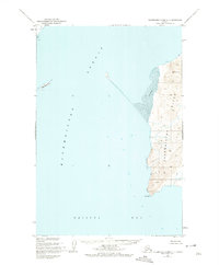
1952 Map of Naknek D-5
USGS Topo · Published 1962About this map
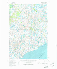
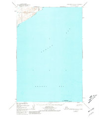
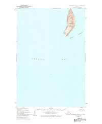
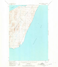
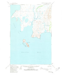
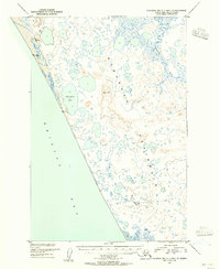
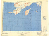
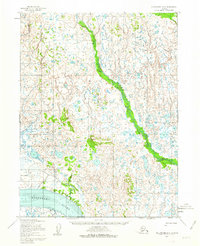
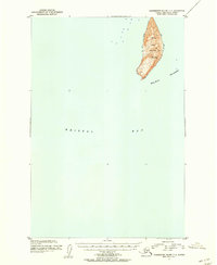
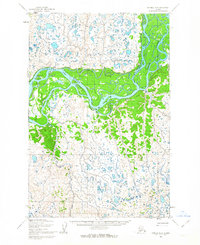
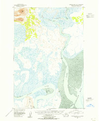
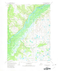
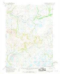
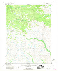
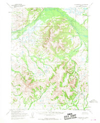
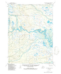
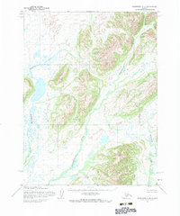
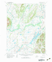
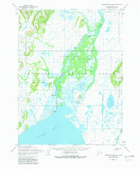
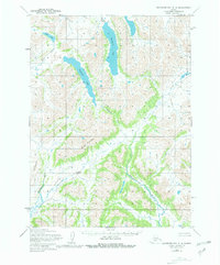
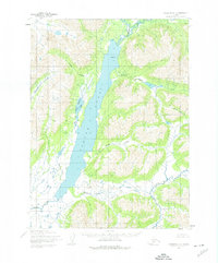
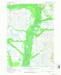
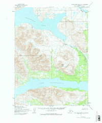
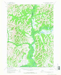
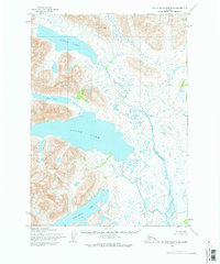
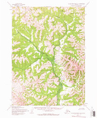
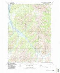
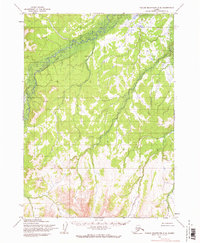
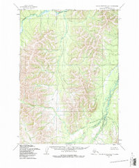
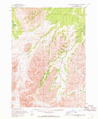
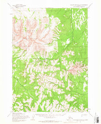
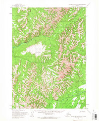
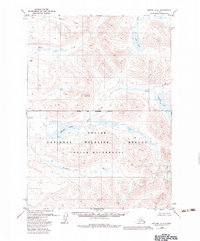
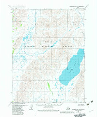
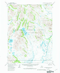
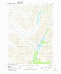
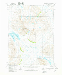
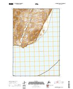
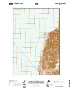
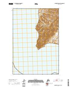
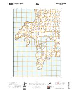
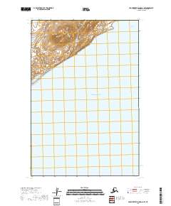
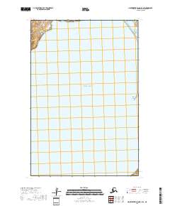
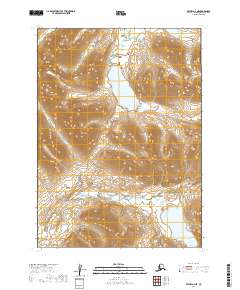
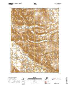
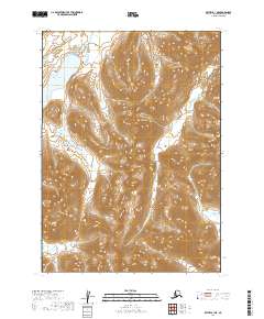
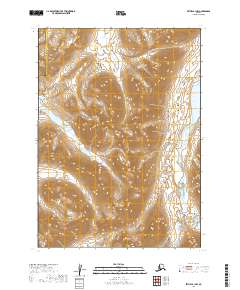
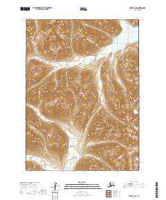
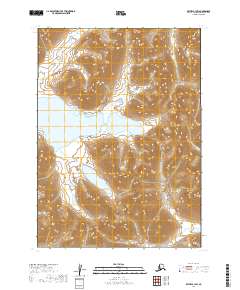
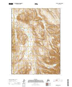
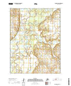
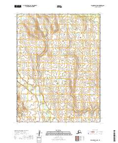
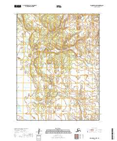
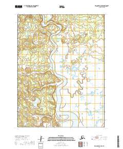
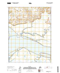
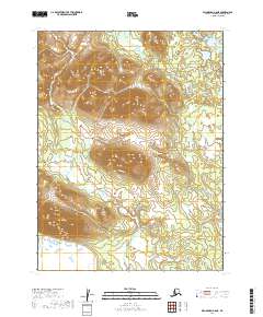
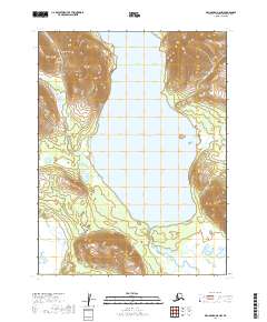
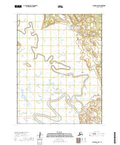
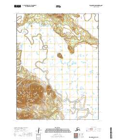
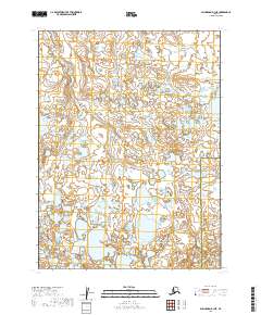
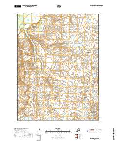
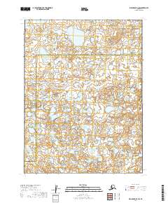
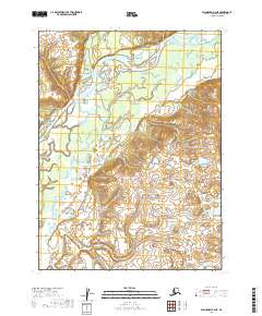
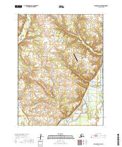
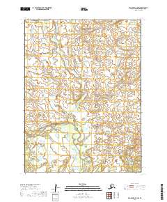
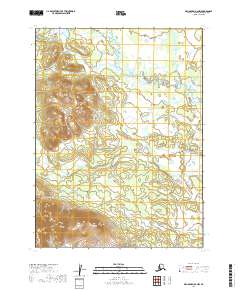
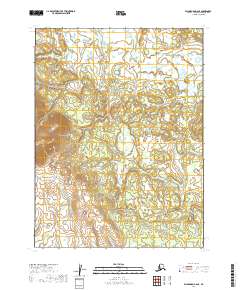
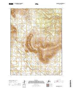
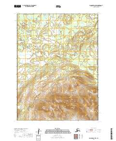
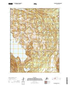
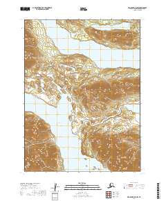
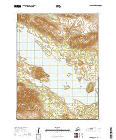
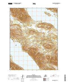
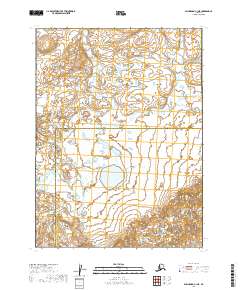
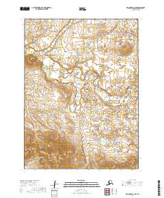
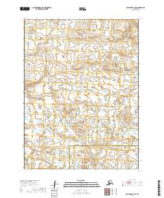
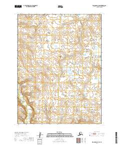
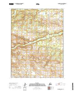
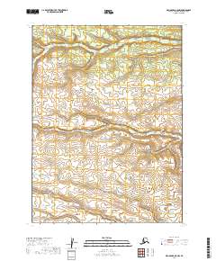
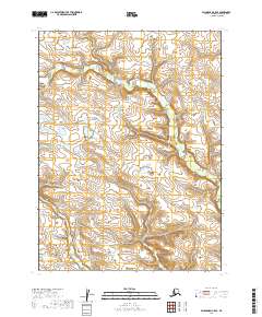
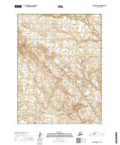
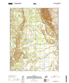
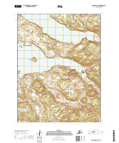
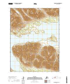
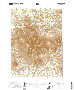
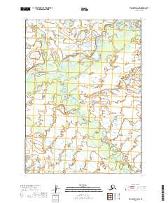
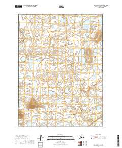
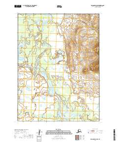
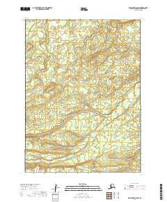
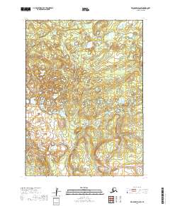
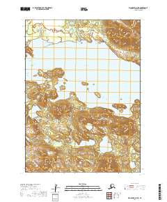
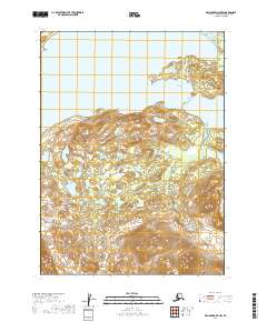
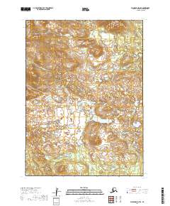
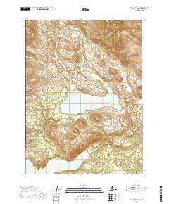
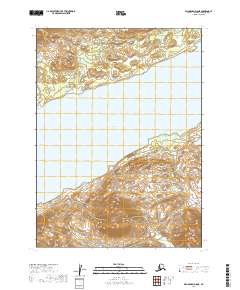
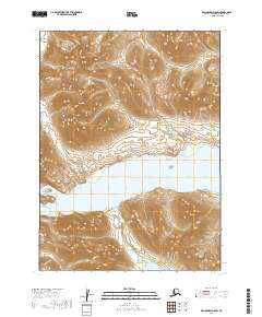
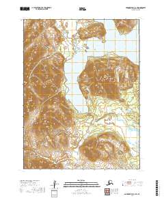
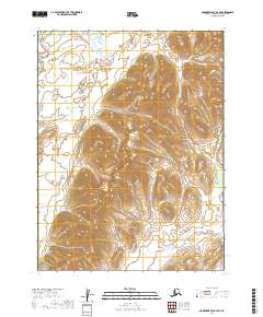
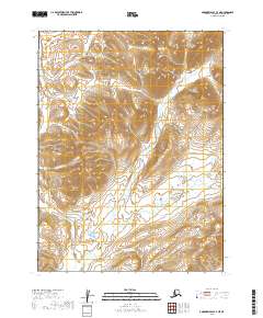
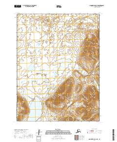
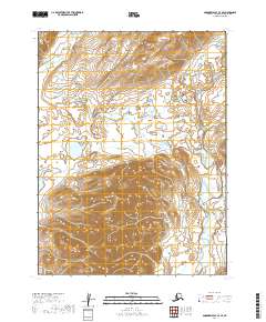
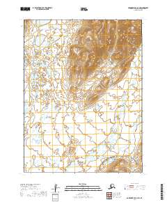
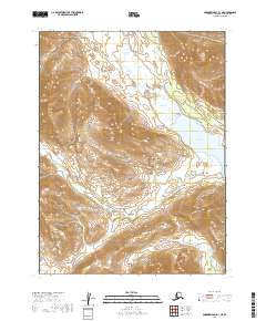
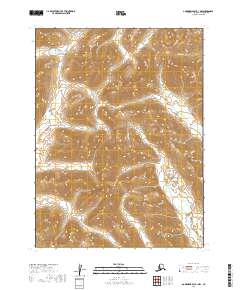
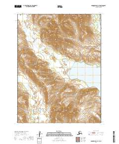
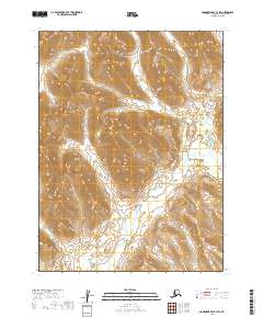
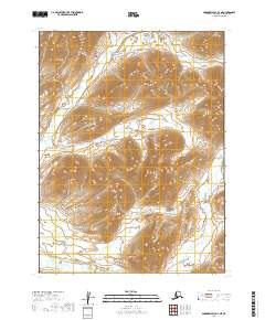
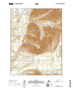
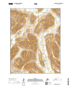
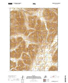
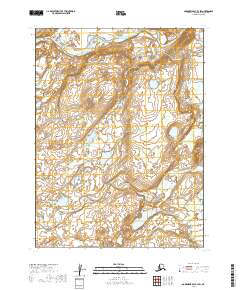
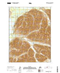
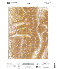
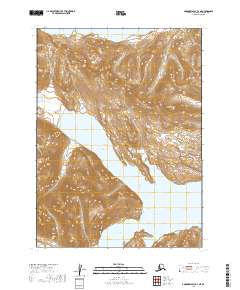
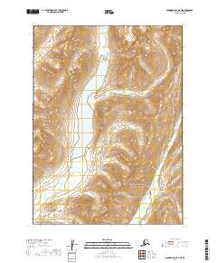
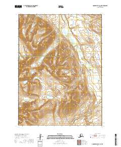
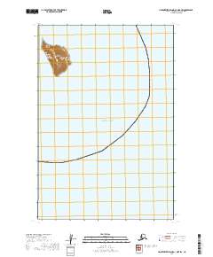
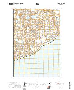
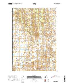
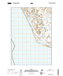
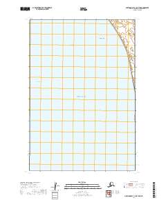
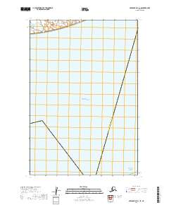
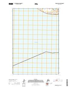
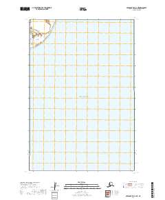
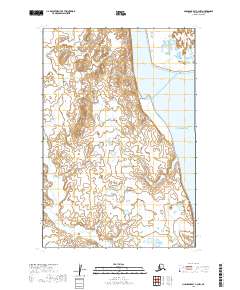
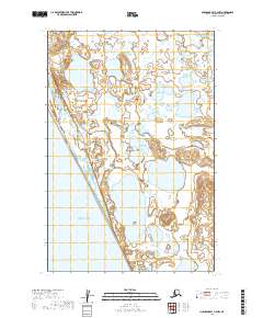
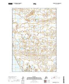
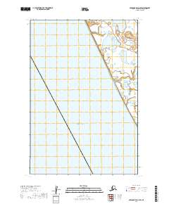
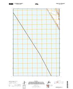
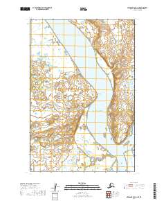
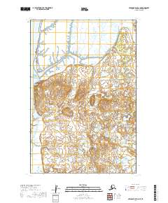
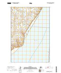
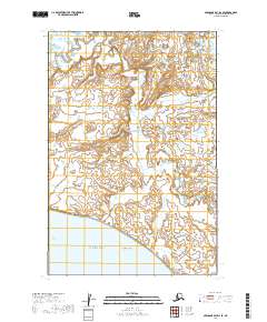
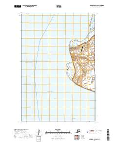
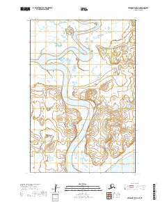
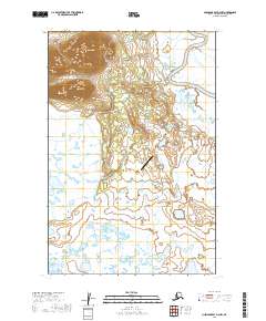
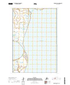
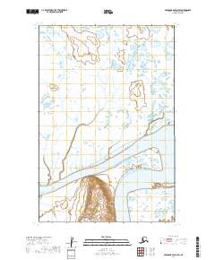
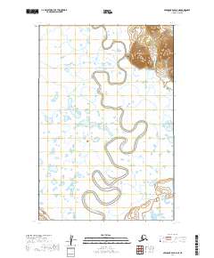
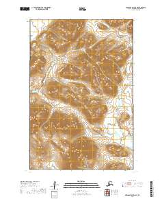
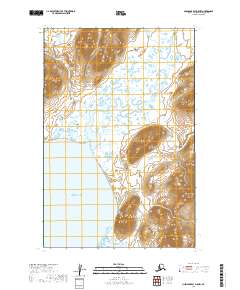
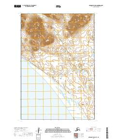
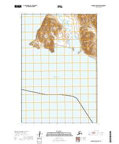
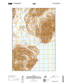
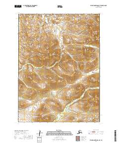
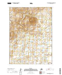
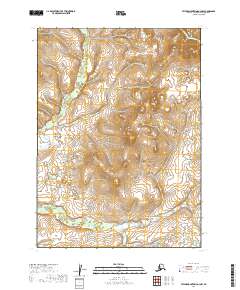
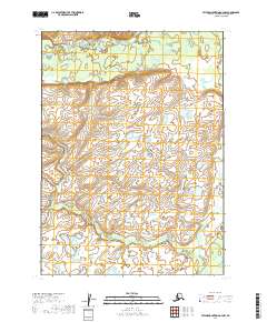
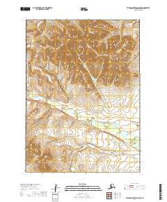
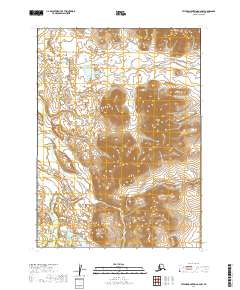
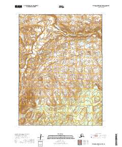
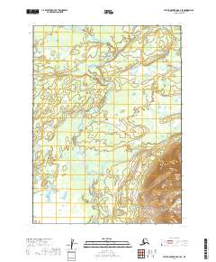
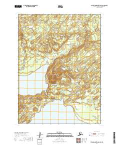
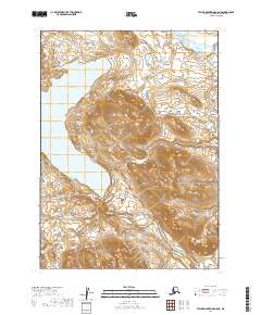
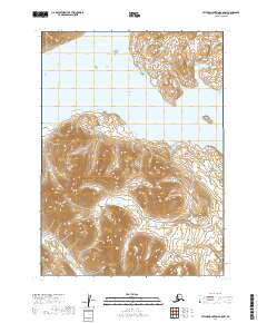
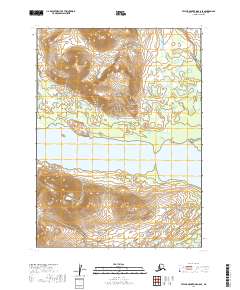
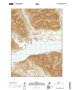
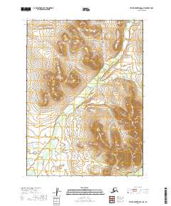
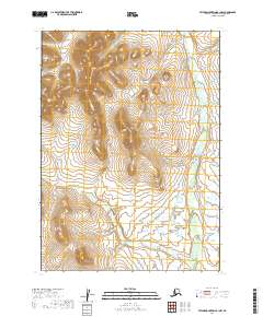
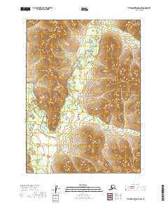
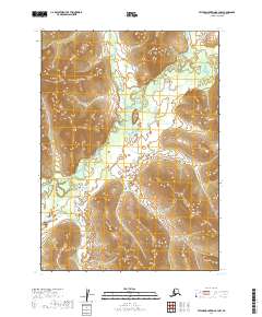
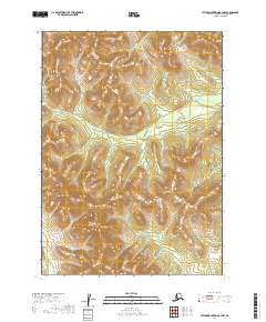
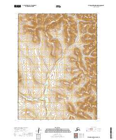
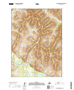
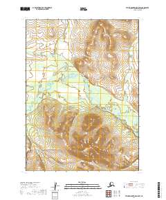
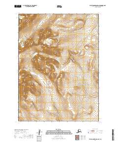
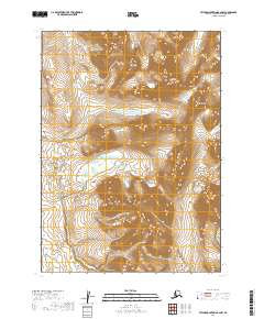
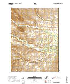
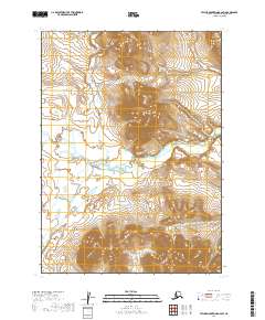
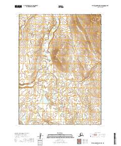
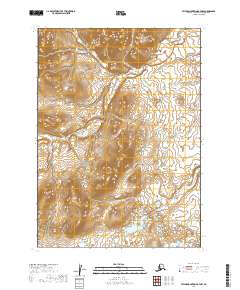
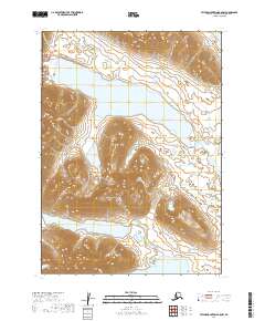
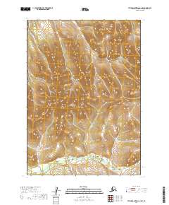
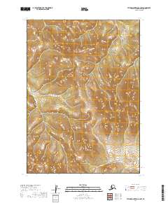
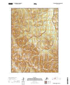
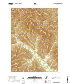
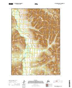
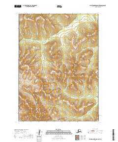
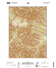
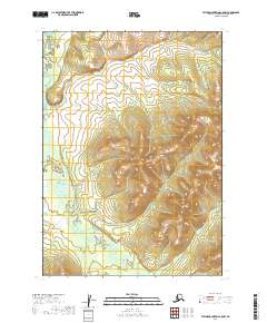
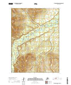
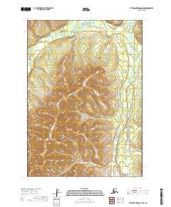
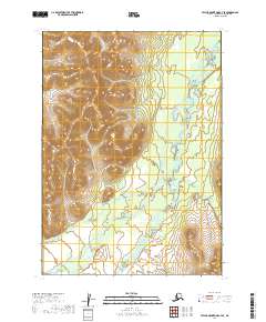
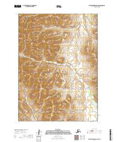
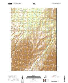
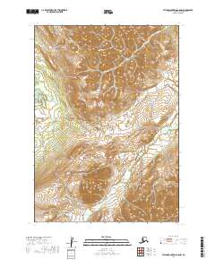
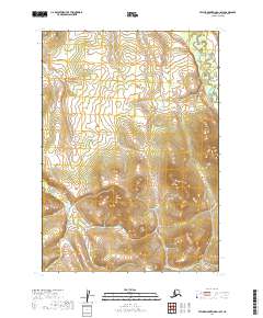
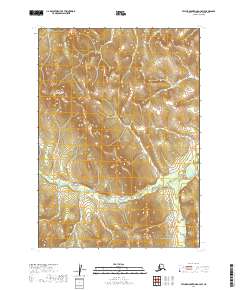
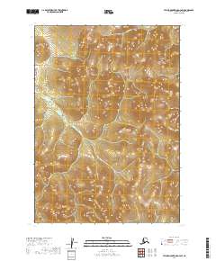
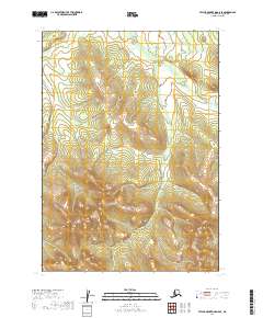
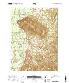
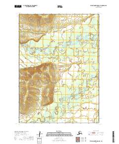
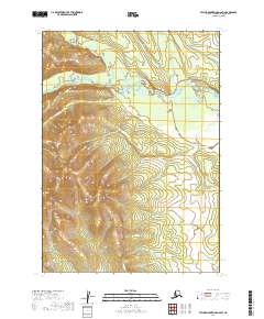
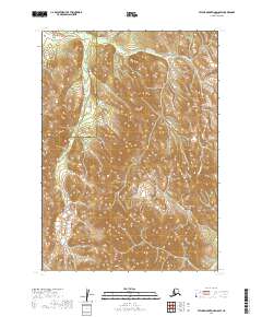
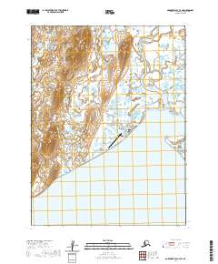
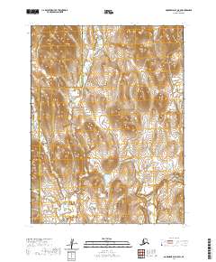
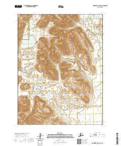
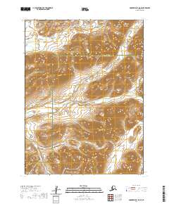
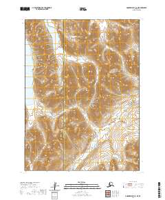
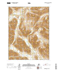
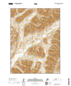
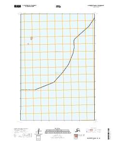
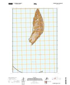
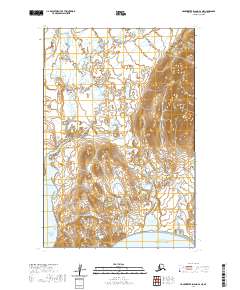
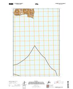
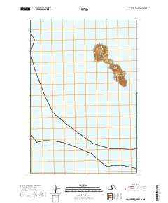
Kvichak Bay dominates the southern reaches of this 1952 topographic survey, revealing a coastline of extensive mud and sand deposits along its northeastern shores. The interior landscape is characterized by an intricate network of countless unnamed small lakes and ponds, typical of the low-lying terrain north of Half Moon Bay. Human presence is notably sparse, marked only by a lone Cabin in the northwest and a seasonal Winter Trail that traverses the northern wetlands. The hydrography of the region is defined by tidal influence and shifting channels, including the prominent Keefer Cutoff and the winding course of Portage Creek. These features suggest a landscape where navigation and travel were dictated by the seasons and the tides, reflecting the remote character of the Alaska Peninsula during the mid-century period.
Find a feature on this map
8 named features on this map. Tap any name to fly to it.
Don’t see what you’re looking for? This feature index may not catch every label — zoom into the map to look around manually.
Map Details
Editions of this 1952 Naknek D-5 Map
This is the sole edition of this map. No revisions or reprints were ever made.
Historical Maps of Unorganized Borough Through Time
487 maps found
1947 Hagemeister Island D-2
Dillingham Borough, AK

1948 Hagemeister Island C-1
Dillingham Borough, AK
1948 Hagemeister Island C-2
Dillingham Borough, AK
1948 Hagemeister Island C-3
Dillingham Borough, AK
1948 Hagemeister Island C-4
Dillingham Borough, AK
1948 Hagemeister Island D-3
Dillingham Borough, AK
1948 Nushagak Bay C-4 And C-5
Dillingham Borough, AK
1948 Nushagak Bay D-3
Dillingham Borough, AK

1948 Nushagak Bay D-4
Dillingham Borough, AK
1950 Hagemeister Island D-1
Dillingham Borough, AK
1950 Nushagak Bay B-3
Dillingham Borough, AK
1950 Nushagak Bay B-4
Dillingham Borough, AK
1950 Nushagak Bay C-3
Dillingham Borough, AK
1950 Nushagak Bay C-4 And C-5
Dillingham Borough, AK
1950 Nushagak Bay D-5
Dillingham Borough, AK
1950 Nushagak Bay D-6
Dillingham Borough, AK

1950 Taylor Mountains
Dillingham Borough, AK
1951 Goodnews
Dillingham Borough, AK
1951 Hagemeister Island
Dillingham Borough, AK
1951 Taylor Mountains
Dillingham Borough, AK
1952 Dillingham A-4
Dillingham Borough, AK
1952 Dillingham A-5
Dillingham Borough, AK
1952 Dillingham A-6
Dillingham Borough, AK
1952 Dillingham A-7
Dillingham Borough, AK
1952 Dillingham A-8
Dillingham Borough, AK
1952 Hagemeister Island C-1
Dillingham Borough, AK
1952 Hagemeister Island C-2
Dillingham Borough, AK
1952 Hagemeister Island C-3
Dillingham Borough, AK
1952 Hagemeister Island C-4
Dillingham Borough, AK
1952 Hagemeister Island D-1
Dillingham Borough, AK
1952 Naknek D-5
Dillingham Borough, AK
1952 Naknek D-6
Dillingham Borough, AK
1952 Nushagak Bay C-1
Dillingham Borough, AK
1952 Nushagak Bay D-1
Dillingham Borough, AK
1952 Nushagak Bay D-2
Dillingham Borough, AK
1952 Nushagak Bay D-3
Dillingham Borough, AK
1952 Nushagak Bay D-4
Dillingham Borough, AK
1953 Hagemeister Island D-2
Dillingham Borough, AK
1954 Dillingham B-3
Dillingham Borough, AK
1954 Dillingham B-4
Dillingham Borough, AK

1954 Dillingham B-5
Dillingham Borough, AK
1954 Dillingham B-6
Dillingham Borough, AK
1954 Dillingham B-7
Dillingham Borough, AK
1954 Dillingham B-8
Dillingham Borough, AK
1954 Dillingham C-1
Dillingham Borough, AK
1954 Dillingham C-2
Dillingham Borough, AK
1954 Dillingham C-3
Dillingham Borough, AK
1954 Dillingham C-4
Dillingham Borough, AK
1954 Dillingham C-5
Dillingham Borough, AK
1954 Dillingham C-6
Dillingham Borough, AK
1954 Dillingham C-7
Dillingham Borough, AK
1954 Dillingham C-8
Dillingham Borough, AK
1954 Dillingham D-1
Dillingham Borough, AK
1954 Dillingham D-2
Dillingham Borough, AK
1954 Dillingham D-3
Dillingham Borough, AK
1954 Dillingham D-4
Dillingham Borough, AK
1954 Dillingham D-5
Dillingham Borough, AK
1954 Dillingham D-6
Dillingham Borough, AK
1954 Dillingham D-7
Dillingham Borough, AK
1954 Dillingham D-8
Dillingham Borough, AK
1954 Goodnews A-3
Dillingham Borough, AK
1954 Goodnews B-3
Dillingham Borough, AK
1954 Goodnews Bay A-4
Dillingham Borough, AK
1954 Goodnews Bay C-4
Dillingham Borough, AK
1954 Goodnews C-2
Dillingham Borough, AK
1954 Taylor Mountains A-1
Dillingham Borough, AK
1954 Taylor Mountains A-2
Dillingham Borough, AK
1954 Taylor Mountains A-3
Dillingham Borough, AK
1954 Taylor Mountains A-4
Dillingham Borough, AK
1954 Taylor Mountains A-5
Dillingham Borough, AK
1954 Taylor Mountains A-6
Dillingham Borough, AK
1954 Taylor Mountains A-7
Dillingham Borough, AK
1954 Taylor Mountains A-8
Dillingham Borough, AK
1954 Taylor Mountains B-1
Dillingham Borough, AK
1954 Taylor Mountains B-2
Dillingham Borough, AK
1954 Taylor Mountains B-3
Dillingham Borough, AK
1954 Taylor Mountains B-4
Dillingham Borough, AK
1954 Taylor Mountains B-5
Dillingham Borough, AK
1954 Taylor Mountains B-6
Dillingham Borough, AK
1954 Taylor Mountains B-7
Dillingham Borough, AK
1954 Taylor Mountains B-8
Dillingham Borough, AK
1954 Taylor Mountains C-1
Dillingham Borough, AK
1954 Taylor Mountains C-2
Dillingham Borough, AK
1954 Taylor Mountains C-3
Dillingham Borough, AK
1954 Taylor Mountains C-4
Dillingham Borough, AK
1954 Taylor Mountains C-5
Dillingham Borough, AK
1954 Taylor Mountains C-6
Dillingham Borough, AK
1954 Taylor Mountains C-7
Dillingham Borough, AK
1954 Taylor Mountains C-8
Dillingham Borough, AK
1954 Taylor Mountains D-1
Dillingham Borough, AK
1954 Taylor Mountains D-2
Dillingham Borough, AK
1954 Taylor Mountains D-3
Dillingham Borough, AK
1954 Taylor Mountains D-4
Dillingham Borough, AK
1954 Taylor Mountains D-5
Dillingham Borough, AK
1954 Taylor Mountains D-6
Dillingham Borough, AK
1954 Taylor Mountains D-7
Dillingham Borough, AK
1954 Taylor Mountains D-8
Dillingham Borough, AK
1954 Taylor Mountains
Dillingham Borough, AK
1957 Hagemeister Island
Dillingham Borough, AK
1979 Bethel A-1
Dillingham Borough, AK
1979 Bethel A-2
Dillingham Borough, AK
1979 Bethel B-1
Dillingham Borough, AK
1979 Bethel C-1
Dillingham Borough, AK
1979 Goodnews Bay A-1
Dillingham Borough, AK
1979 Goodnews Bay A-2
Dillingham Borough, AK
1979 Goodnews Bay A-5
Dillingham Borough, AK
1979 Goodnews Bay B-1
Dillingham Borough, AK
1979 Goodnews Bay B-2
Dillingham Borough, AK
1979 Goodnews Bay B-4
Dillingham Borough, AK
1979 Goodnews Bay C-1
Dillingham Borough, AK
1979 Goodnews Bay C-3
Dillingham Borough, AK
1979 Goodnews Bay D-1
Dillingham Borough, AK
1979 Goodnews Bay D-2
Dillingham Borough, AK
1979 Goodnews Bay D-3
Dillingham Borough, AK

1979 Goodnews Bay
Dillingham Borough, AK
2018 Hagemeister Island C-3 NE
Dillingham Borough, AK
2018 Hagemeister Island C-3 NW
Dillingham Borough, AK
2018 Hagemeister Island C-3 SW
Dillingham Borough, AK
2018 Hagemeister Island C-4 NE
Dillingham Borough, AK
2018 Hagemeister Island C-4 SE
Dillingham Borough, AK
2018 Hagemeister Island D-1 NW
Dillingham Borough, AK
2018 Hagemeister Island D-2 NW
Dillingham Borough, AK
2018 Hagemeister Island D-3 NE
Dillingham Borough, AK
2018 Hagemeister Island D-3 NW
Dillingham Borough, AK
2018 Hagemeister Island D-3 SE
Dillingham Borough, AK
2018 Hagemeister Island D-3 SW
Dillingham Borough, AK

2019 Bethel A-1 NE
Dillingham Borough, AK
2019 Bethel A-1 NW
Dillingham Borough, AK
2019 Bethel A-1 SE
Dillingham Borough, AK
2019 Bethel A-1 SW
Dillingham Borough, AK
2019 Bethel A-2 NE
Dillingham Borough, AK
2019 Bethel A-2 NW
Dillingham Borough, AK
2019 Bethel A-2 SE
Dillingham Borough, AK
2019 Bethel A-2 SW
Dillingham Borough, AK
2019 Bethel A-3 SE
Dillingham Borough, AK
2019 Bethel B-1 NE
Dillingham Borough, AK
2019 Bethel B-1 NW
Dillingham Borough, AK
2019 Bethel B-1 SE
Dillingham Borough, AK
2019 Bethel B-1 SW
Dillingham Borough, AK
2019 Bethel B-2 SE
Dillingham Borough, AK
2019 Bethel C-1 NE
Dillingham Borough, AK
2019 Bethel C-1 SE
Dillingham Borough, AK
2019 Bethel C-1 SW
Dillingham Borough, AK
2019 Dillingham A-4 NW
Dillingham Borough, AK
2019 Dillingham A-4 SE
Dillingham Borough, AK
2019 Dillingham A-4 SW
Dillingham Borough, AK
2019 Dillingham A-5 NE
Dillingham Borough, AK
2019 Dillingham A-5 NW
Dillingham Borough, AK
2019 Dillingham A-5 SE
Dillingham Borough, AK
2019 Dillingham A-5 SW
Dillingham Borough, AK
2019 Dillingham A-6 NE
Dillingham Borough, AK
2019 Dillingham A-6 NW
Dillingham Borough, AK
2019 Dillingham A-6 SE
Dillingham Borough, AK
2019 Dillingham A-6 SW
Dillingham Borough, AK
2019 Dillingham A-7 NE
Dillingham Borough, AK
2019 Dillingham A-7 NW
Dillingham Borough, AK
2019 Dillingham A-7 SE
Dillingham Borough, AK
2019 Dillingham A-7 SW
Dillingham Borough, AK
2019 Dillingham A-8 NE
Dillingham Borough, AK
2019 Dillingham A-8 NW
Dillingham Borough, AK
2019 Dillingham A-8 SE
Dillingham Borough, AK
2019 Dillingham A-8 SW
Dillingham Borough, AK
2019 Dillingham B-3 NE
Dillingham Borough, AK
2019 Dillingham B-3 NW
Dillingham Borough, AK
2019 Dillingham B-3 SW
Dillingham Borough, AK
2019 Dillingham B-4 NE
Dillingham Borough, AK
2019 Dillingham B-4 NW
Dillingham Borough, AK
2019 Dillingham B-4 SE
Dillingham Borough, AK
2019 Dillingham B-4 SW
Dillingham Borough, AK
2019 Dillingham B-5 NE
Dillingham Borough, AK
2019 Dillingham B-5 NW
Dillingham Borough, AK
2019 Dillingham B-5 SE
Dillingham Borough, AK
2019 Dillingham B-5 SW
Dillingham Borough, AK
2019 Dillingham B-6 NE
Dillingham Borough, AK
2019 Dillingham B-6 NW
Dillingham Borough, AK
2019 Dillingham B-6 SE
Dillingham Borough, AK
2019 Dillingham B-6 SW
Dillingham Borough, AK
2019 Dillingham B-7 NE
Dillingham Borough, AK
2019 Dillingham B-7 NW
Dillingham Borough, AK
2019 Dillingham B-7 SE
Dillingham Borough, AK
2019 Dillingham B-7 SW
Dillingham Borough, AK
2019 Dillingham B-8 NE
Dillingham Borough, AK
2019 Dillingham B-8 NW
Dillingham Borough, AK
2019 Dillingham B-8 SE
Dillingham Borough, AK
2019 Dillingham B-8 SW
Dillingham Borough, AK
2019 Dillingham C-1 NE
Dillingham Borough, AK
2019 Dillingham C-1 NW
Dillingham Borough, AK
2019 Dillingham C-2 NE
Dillingham Borough, AK
2019 Dillingham C-2 NW
Dillingham Borough, AK
2019 Dillingham C-2 SE
Dillingham Borough, AK
2019 Dillingham C-2 SW
Dillingham Borough, AK
2019 Dillingham C-3 NE
Dillingham Borough, AK
2019 Dillingham C-3 NW
Dillingham Borough, AK
2019 Dillingham C-3 SE
Dillingham Borough, AK
2019 Dillingham C-3 SW
Dillingham Borough, AK
2019 Dillingham C-4 NE
Dillingham Borough, AK
2019 Dillingham C-4 NW
Dillingham Borough, AK
2019 Dillingham C-4 SE
Dillingham Borough, AK
2019 Dillingham C-4 SW
Dillingham Borough, AK
2019 Dillingham C-5 NE
Dillingham Borough, AK
2019 Dillingham C-5 NW
Dillingham Borough, AK
2019 Dillingham C-5 SE
Dillingham Borough, AK
2019 Dillingham C-5 SW
Dillingham Borough, AK
2019 Dillingham C-6 NE
Dillingham Borough, AK
2019 Dillingham C-6 NW
Dillingham Borough, AK
2019 Dillingham C-6 SE
Dillingham Borough, AK
2019 Dillingham C-6 SW
Dillingham Borough, AK
2019 Dillingham C-7 NE
Dillingham Borough, AK
2019 Dillingham C-7 NW
Dillingham Borough, AK
2019 Dillingham C-7 SE
Dillingham Borough, AK
2019 Dillingham C-7 SW
Dillingham Borough, AK
2019 Dillingham C-8 NE
Dillingham Borough, AK
2019 Dillingham C-8 NW
Dillingham Borough, AK
2019 Dillingham C-8 SE
Dillingham Borough, AK
2019 Dillingham C-8 SW
Dillingham Borough, AK
2019 Dillingham D-1 NE
Dillingham Borough, AK
2019 Dillingham D-1 NW
Dillingham Borough, AK
2019 Dillingham D-1 SE
Dillingham Borough, AK
2019 Dillingham D-1 SW
Dillingham Borough, AK
2019 Dillingham D-2 NE
Dillingham Borough, AK
2019 Dillingham D-2 NW
Dillingham Borough, AK
2019 Dillingham D-2 SE
Dillingham Borough, AK
2019 Dillingham D-2 SW
Dillingham Borough, AK
2019 Dillingham D-3 NE
Dillingham Borough, AK
2019 Dillingham D-3 NW
Dillingham Borough, AK
2019 Dillingham D-3 SE
Dillingham Borough, AK
2019 Dillingham D-3 SW
Dillingham Borough, AK
2019 Dillingham D-4 NE
Dillingham Borough, AK
2019 Dillingham D-4 NW
Dillingham Borough, AK
2019 Dillingham D-4 SE
Dillingham Borough, AK
2019 Dillingham D-4 SW
Dillingham Borough, AK
2019 Dillingham D-5 NE
Dillingham Borough, AK
2019 Dillingham D-5 NW
Dillingham Borough, AK
2019 Dillingham D-5 SE
Dillingham Borough, AK
2019 Dillingham D-5 SW
Dillingham Borough, AK
2019 Dillingham D-6 NE
Dillingham Borough, AK
2019 Dillingham D-6 NW
Dillingham Borough, AK
2019 Dillingham D-6 SE
Dillingham Borough, AK
2019 Dillingham D-6 SW
Dillingham Borough, AK
2019 Dillingham D-7 NE
Dillingham Borough, AK
2019 Dillingham D-7 NW
Dillingham Borough, AK
2019 Dillingham D-7 SE
Dillingham Borough, AK
2019 Dillingham D-7 SW
Dillingham Borough, AK
2019 Dillingham D-8 NE
Dillingham Borough, AK
2019 Dillingham D-8 NW
Dillingham Borough, AK
2019 Dillingham D-8 SE
Dillingham Borough, AK
2019 Dillingham D-8 SW
Dillingham Borough, AK
2019 Goodnews Bay A-1 NE
Dillingham Borough, AK
2019 Goodnews Bay A-1 NW
Dillingham Borough, AK
2019 Goodnews Bay A-1 SE
Dillingham Borough, AK
2019 Goodnews Bay A-1 SW
Dillingham Borough, AK
2019 Goodnews Bay A-2 NE
Dillingham Borough, AK
2019 Goodnews Bay A-2 NW
Dillingham Borough, AK
2019 Goodnews Bay A-2 SE
Dillingham Borough, AK
2019 Goodnews Bay A-2 SW
Dillingham Borough, AK
2019 Goodnews Bay A-3 NE
Dillingham Borough, AK
2019 Goodnews Bay A-3 NW
Dillingham Borough, AK
2019 Goodnews Bay A-3 SE
Dillingham Borough, AK
2019 Goodnews Bay A-3 SW
Dillingham Borough, AK
2019 Goodnews Bay B-1 NE
Dillingham Borough, AK
2019 Goodnews Bay B-1 NW
Dillingham Borough, AK
2019 Goodnews Bay B-1 SE
Dillingham Borough, AK
2019 Goodnews Bay B-1 SW
Dillingham Borough, AK
2019 Goodnews Bay B-2 NE
Dillingham Borough, AK
2019 Goodnews Bay B-2 NW
Dillingham Borough, AK
2019 Goodnews Bay B-2 SE
Dillingham Borough, AK
2019 Goodnews Bay B-2 SW
Dillingham Borough, AK
2019 Goodnews Bay B-3 NE
Dillingham Borough, AK
2019 Goodnews Bay B-3 NW
Dillingham Borough, AK
2019 Goodnews Bay B-3 SE
Dillingham Borough, AK
2019 Goodnews Bay B-3 SW
Dillingham Borough, AK
2019 Goodnews Bay C-1 NE
Dillingham Borough, AK
2019 Goodnews Bay C-1 NW
Dillingham Borough, AK

2019 Goodnews Bay C-1 SE
Dillingham Borough, AK
2019 Goodnews Bay C-1 SW
Dillingham Borough, AK
2019 Goodnews Bay C-2 NE
Dillingham Borough, AK
2019 Goodnews Bay C-2 NW
Dillingham Borough, AK
2019 Goodnews Bay C-2 SE
Dillingham Borough, AK
2019 Goodnews Bay C-2 SW
Dillingham Borough, AK
2019 Goodnews Bay C-3 NE
Dillingham Borough, AK
2019 Goodnews Bay C-3 NW
Dillingham Borough, AK
2019 Goodnews Bay C-3 SE
Dillingham Borough, AK
2019 Goodnews Bay C-3 SW
Dillingham Borough, AK
2019 Goodnews Bay D-1 NE
Dillingham Borough, AK
2019 Goodnews Bay D-1 NW
Dillingham Borough, AK
2019 Goodnews Bay D-1 SE
Dillingham Borough, AK
2019 Goodnews Bay D-1 SW
Dillingham Borough, AK
2019 Goodnews Bay D-2 NE
Dillingham Borough, AK
2019 Goodnews Bay D-2 NW
Dillingham Borough, AK
2019 Goodnews Bay D-2 SE
Dillingham Borough, AK
2019 Goodnews Bay D-2 SW
Dillingham Borough, AK
2019 Goodnews Bay D-3 NE
Dillingham Borough, AK
2019 Goodnews Bay D-3 SE
Dillingham Borough, AK
2019 Goodnews Bay D-3 SW
Dillingham Borough, AK
2019 Hagemeister Island C-1 OE E NW
Dillingham Borough, AK
2019 Hagemeister Island C-1 OE E SW
Dillingham Borough, AK
2019 Naknek C-6 NW
Dillingham Borough, AK
2019 Naknek D-5 NE
Dillingham Borough, AK
2019 Naknek D-5 NW
Dillingham Borough, AK
2019 Naknek D-5 SE
Dillingham Borough, AK
2019 Naknek D-5 SW
Dillingham Borough, AK
2019 Naknek D-6 NE
Dillingham Borough, AK
2019 Naknek D-6 NW
Dillingham Borough, AK
2019 Naknek D-6 SE
Dillingham Borough, AK
2019 Naknek D-6 SW
Dillingham Borough, AK
2019 Nushagak Bay B-3 NE
Dillingham Borough, AK
2019 Nushagak Bay B-3 NW
Dillingham Borough, AK
2019 Nushagak Bay B-4 NE
Dillingham Borough, AK
2019 Nushagak Bay B-4 NW
Dillingham Borough, AK
2019 Nushagak Bay C-1 NE
Dillingham Borough, AK
2019 Nushagak Bay C-1 NW
Dillingham Borough, AK
2019 Nushagak Bay C-1 OE W NE
Dillingham Borough, AK
2019 Nushagak Bay C-1 SE
Dillingham Borough, AK
2019 Nushagak Bay C-1 SW
Dillingham Borough, AK
2019 Nushagak Bay C-3 NE
Dillingham Borough, AK
2019 Nushagak Bay C-3 NW
Dillingham Borough, AK
2019 Nushagak Bay C-3 SE
Dillingham Borough, AK
2019 Nushagak Bay C-3 SW
Dillingham Borough, AK
2019 Nushagak Bay C-4 NE
Dillingham Borough, AK
2019 Nushagak Bay C-4 NW
Dillingham Borough, AK
2019 Nushagak Bay C-4 SE
Dillingham Borough, AK
2019 Nushagak Bay C-4 SW
Dillingham Borough, AK
2019 Nushagak Bay C-5 NE
Dillingham Borough, AK
2019 Nushagak Bay D-1 NE
Dillingham Borough, AK
2019 Nushagak Bay D-1 NW
Dillingham Borough, AK
2019 Nushagak Bay D-1 SE
Dillingham Borough, AK
2019 Nushagak Bay D-1 SW
Dillingham Borough, AK
2019 Nushagak Bay D-2 NE
Dillingham Borough, AK
2019 Nushagak Bay D-2 NW
Dillingham Borough, AK
2019 Nushagak Bay D-2 SE
Dillingham Borough, AK
2019 Nushagak Bay D-2 SW
Dillingham Borough, AK
2019 Nushagak Bay D-3 NE
Dillingham Borough, AK
2019 Nushagak Bay D-3 NW
Dillingham Borough, AK
2019 Nushagak Bay D-3 SE
Dillingham Borough, AK
2019 Nushagak Bay D-3 SW
Dillingham Borough, AK
2019 Nushagak Bay D-4 NE
Dillingham Borough, AK
2019 Nushagak Bay D-4 NW
Dillingham Borough, AK
2019 Nushagak Bay D-4 SE
Dillingham Borough, AK
2019 Nushagak Bay D-4 SW
Dillingham Borough, AK
2019 Nushagak Bay D-5 NE
Dillingham Borough, AK
2019 Nushagak Bay D-5 NW
Dillingham Borough, AK
2019 Nushagak Bay D-5 SE
Dillingham Borough, AK
2019 Nushagak Bay D-5 SW
Dillingham Borough, AK
2019 Nushagak Bay D-6 NE
Dillingham Borough, AK
2019 Nushagak Bay D-6 NW
Dillingham Borough, AK
2019 Nushagak Bay D-6 SE
Dillingham Borough, AK
2019 Nushagak Bay D-6 SW
Dillingham Borough, AK
2019 Taylor Mountains A-1 NE
Dillingham Borough, AK
2019 Taylor Mountains A-1 NW
Dillingham Borough, AK
2019 Taylor Mountains A-1 SE
Dillingham Borough, AK
2019 Taylor Mountains A-1 SW
Dillingham Borough, AK
2019 Taylor Mountains A-2 NE
Dillingham Borough, AK
2019 Taylor Mountains A-2 NW
Dillingham Borough, AK
2019 Taylor Mountains A-2 SE
Dillingham Borough, AK

2019 Taylor Mountains A-2 SW
Dillingham Borough, AK
2019 Taylor Mountains A-3 NE
Dillingham Borough, AK
2019 Taylor Mountains A-3 NW
Dillingham Borough, AK
2019 Taylor Mountains A-3 SE
Dillingham Borough, AK
2019 Taylor Mountains A-3 SW
Dillingham Borough, AK
2019 Taylor Mountains A-4 NE
Dillingham Borough, AK
2019 Taylor Mountains A-4 NW
Dillingham Borough, AK
2019 Taylor Mountains A-4 SE
Dillingham Borough, AK
2019 Taylor Mountains A-4 SW
Dillingham Borough, AK
2019 Taylor Mountains A-5 NE
Dillingham Borough, AK
2019 Taylor Mountains A-5 NW
Dillingham Borough, AK
2019 Taylor Mountains A-5 SE
Dillingham Borough, AK
2019 Taylor Mountains A-5 SW
Dillingham Borough, AK
2019 Taylor Mountains A-6 NE
Dillingham Borough, AK
2019 Taylor Mountains A-6 NW
Dillingham Borough, AK
2019 Taylor Mountains A-6 SE
Dillingham Borough, AK
2019 Taylor Mountains A-6 SW
Dillingham Borough, AK
2019 Taylor Mountains A-7 NE
Dillingham Borough, AK
2019 Taylor Mountains A-7 NW
Dillingham Borough, AK
2019 Taylor Mountains A-7 SE
Dillingham Borough, AK
2019 Taylor Mountains A-7 SW
Dillingham Borough, AK
2019 Taylor Mountains A-8 NE
Dillingham Borough, AK
2019 Taylor Mountains A-8 NW
Dillingham Borough, AK
2019 Taylor Mountains A-8 SE
Dillingham Borough, AK
2019 Taylor Mountains A-8 SW
Dillingham Borough, AK
2019 Taylor Mountains B-1 NE
Dillingham Borough, AK
2019 Taylor Mountains B-1 NW
Dillingham Borough, AK
2019 Taylor Mountains B-1 SE
Dillingham Borough, AK
2019 Taylor Mountains B-1 SW
Dillingham Borough, AK
2019 Taylor Mountains B-2 NE
Dillingham Borough, AK
2019 Taylor Mountains B-2 NW
Dillingham Borough, AK
2019 Taylor Mountains B-2 SE
Dillingham Borough, AK
2019 Taylor Mountains B-2 SW
Dillingham Borough, AK
2019 Taylor Mountains B-3 NE
Dillingham Borough, AK
2019 Taylor Mountains B-3 NW
Dillingham Borough, AK
2019 Taylor Mountains B-3 SE
Dillingham Borough, AK
2019 Taylor Mountains B-3 SW
Dillingham Borough, AK
2019 Taylor Mountains B-4 NE
Dillingham Borough, AK
2019 Taylor Mountains B-4 NW
Dillingham Borough, AK
2019 Taylor Mountains B-4 SE
Dillingham Borough, AK
2019 Taylor Mountains B-4 SW
Dillingham Borough, AK
2019 Taylor Mountains B-5 NE
Dillingham Borough, AK
2019 Taylor Mountains B-5 NW
Dillingham Borough, AK
2019 Taylor Mountains B-5 SE
Dillingham Borough, AK
2019 Taylor Mountains B-5 SW
Dillingham Borough, AK
2019 Taylor Mountains B-6 NE
Dillingham Borough, AK
2019 Taylor Mountains B-6 NW
Dillingham Borough, AK
2019 Taylor Mountains B-6 SE
Dillingham Borough, AK
2019 Taylor Mountains B-6 SW
Dillingham Borough, AK
2019 Taylor Mountains B-7 NE
Dillingham Borough, AK
2019 Taylor Mountains B-7 NW
Dillingham Borough, AK
2019 Taylor Mountains B-7 SE
Dillingham Borough, AK
2019 Taylor Mountains B-7 SW
Dillingham Borough, AK
2019 Taylor Mountains B-8 NE
Dillingham Borough, AK
2019 Taylor Mountains B-8 NW
Dillingham Borough, AK
2019 Taylor Mountains B-8 SE
Dillingham Borough, AK
2019 Taylor Mountains B-8 SW
Dillingham Borough, AK
2019 Taylor Mountains C-1 NE
Dillingham Borough, AK
2019 Taylor Mountains C-1 NW
Dillingham Borough, AK
2019 Taylor Mountains C-1 SE
Dillingham Borough, AK
2019 Taylor Mountains C-1 SW
Dillingham Borough, AK
2019 Taylor Mountains C-2 NE
Dillingham Borough, AK
2019 Taylor Mountains C-2 NW
Dillingham Borough, AK
2019 Taylor Mountains C-2 SE
Dillingham Borough, AK
2019 Taylor Mountains C-2 SW
Dillingham Borough, AK
2019 Taylor Mountains C-3 NE
Dillingham Borough, AK
2019 Taylor Mountains C-3 NW
Dillingham Borough, AK
2019 Taylor Mountains C-3 SE
Dillingham Borough, AK
2019 Taylor Mountains C-3 SW
Dillingham Borough, AK
2019 Taylor Mountains C-4 NE
Dillingham Borough, AK
2019 Taylor Mountains C-4 NW
Dillingham Borough, AK
2019 Taylor Mountains C-4 SE
Dillingham Borough, AK
2019 Taylor Mountains C-4 SW
Dillingham Borough, AK
2019 Taylor Mountains C-5 NE
Dillingham Borough, AK
2019 Taylor Mountains C-5 NW
Dillingham Borough, AK
2019 Taylor Mountains C-5 SE
Dillingham Borough, AK
2019 Taylor Mountains C-5 SW
Dillingham Borough, AK
2019 Taylor Mountains C-6 NE
Dillingham Borough, AK
2019 Taylor Mountains C-6 NW
Dillingham Borough, AK
2019 Taylor Mountains C-6 SE
Dillingham Borough, AK
2019 Taylor Mountains C-6 SW
Dillingham Borough, AK
2019 Taylor Mountains C-7 NE
Dillingham Borough, AK
2019 Taylor Mountains C-7 NW
Dillingham Borough, AK
2019 Taylor Mountains C-7 SE
Dillingham Borough, AK
2019 Taylor Mountains C-7 SW
Dillingham Borough, AK
2019 Taylor Mountains C-8 NE
Dillingham Borough, AK
2019 Taylor Mountains C-8 NW
Dillingham Borough, AK
2019 Taylor Mountains C-8 SE
Dillingham Borough, AK
2019 Taylor Mountains C-8 SW
Dillingham Borough, AK
2019 Taylor Mountains D-1 SE
Dillingham Borough, AK
2019 Taylor Mountains D-1 SW
Dillingham Borough, AK
2019 Taylor Mountains D-2 SE
Dillingham Borough, AK
2019 Taylor Mountains D-2 SW
Dillingham Borough, AK
2019 Taylor Mountains D-3 SE
Dillingham Borough, AK
2019 Taylor Mountains D-3 SW
Dillingham Borough, AK
2019 Taylor Mountains D-4 NE
Dillingham Borough, AK
2019 Taylor Mountains D-4 NW
Dillingham Borough, AK
2019 Taylor Mountains D-4 SE
Dillingham Borough, AK
2019 Taylor Mountains D-4 SW
Dillingham Borough, AK
2019 Taylor Mountains D-5 SE
Dillingham Borough, AK
2019 Taylor Mountains D-5 SW
Dillingham Borough, AK
2019 Taylor Mountains D-6 SE
Dillingham Borough, AK
2019 Taylor Mountains D-6 SW
Dillingham Borough, AK
2019 Taylor Mountains D-7 SE
Dillingham Borough, AK
2019 Taylor Mountains D-7 SW
Dillingham Borough, AK
2019 Taylor Mountains D-8 SE
Dillingham Borough, AK
2019 Taylor Mountains D-8 SW
Dillingham Borough, AK
2020 Goodnews Bay A-4 NE
Dillingham Borough, AK
2020 Goodnews Bay A-4 NW
Dillingham Borough, AK
2020 Goodnews Bay A-4 SE
Dillingham Borough, AK
2020 Goodnews Bay A-4 SW
Dillingham Borough, AK
2020 Goodnews Bay A-5 NE
Dillingham Borough, AK
2020 Goodnews Bay A-5 NW
Dillingham Borough, AK
2020 Goodnews Bay A-5 SE
Dillingham Borough, AK
2020 Goodnews Bay A-5 SW
Dillingham Borough, AK
2020 Goodnews Bay B-4 NE
Dillingham Borough, AK
2020 Goodnews Bay B-4 NW
Dillingham Borough, AK
2020 Goodnews Bay B-4 SE
Dillingham Borough, AK
2020 Goodnews Bay B-4 SW
Dillingham Borough, AK
2020 Goodnews Bay B-5 SE
Dillingham Borough, AK
2020 Goodnews Bay C-4 NE
Dillingham Borough, AK
2020 Goodnews Bay C-4 SE
Dillingham Borough, AK
2020 Goodnews Bay C-4 SW
Dillingham Borough, AK
2020 Hagemeister Island C-1 NE
Dillingham Borough, AK
2020 Hagemeister Island C-1 NW
Dillingham Borough, AK
2020 Hagemeister Island C-1 SE
Dillingham Borough, AK
2020 Hagemeister Island C-1 SW
Dillingham Borough, AK
2020 Hagemeister Island C-2 NE
Dillingham Borough, AK
2020 Hagemeister Island D-1 NE
Dillingham Borough, AK
2020 Hagemeister Island D-1 SE
Dillingham Borough, AK
2020 Hagemeister Island D-1 SW
Dillingham Borough, AK
2020 Hagemeister Island D-2 SE
Dillingham Borough, AK
2023 Dillingham A-7 SW
Dillingham Borough, AK