
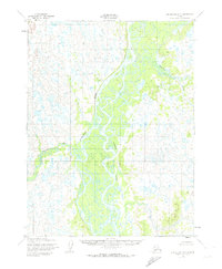
1952 Map of Dillingham A-5
USGS Topo · Published 1958About this map
The Nushagak River dominates this mid-century landscape in the Dillingham region of Alaska, shown here as a complex network of braided channels and seasonal waterways. A single Cabin stands as the only named structure in this expansive riverine environment, positioned near the confluence where the Iowithla River meets the main channel. The detailed mapping of the Keefer Cutoff illustrates the shifting nature of the local hydrology, where water levels and sandbars define the navigable routes. This 1952 field survey provides a baseline of the area's geography before significant modern environmental changes, offering a view of the terrain as it was known to early aviators and river travelers in the Third Judicial Division.
Find a feature on this map
4 named features on this map. Tap any name to fly to it.
Don’t see what you’re looking for? This feature index may not catch every label — zoom into the map to look around manually.
Map Details
Editions of this 1952 Dillingham A-5 Map
2 editions found
Other maps of this area

1951 · Dillingham
USGS Topo · 1:250,000

1952 · Naknek
USGS Topo · 1:250,000

1952 · Dillingham A-4
USGS Topo · 1:63,360

1952 · Naknek D-5
USGS Topo · 1:63,360

1952 · Dillingham A-6
USGS Topo · 1:63,360

1952 · Naknek D-6
USGS Topo · 1:63,360

1954 · Dillingham
USGS Topo · 1:250,000

1954 · Dillingham B-4
USGS Topo · 1:63,360

1954 · Dillingham B-6
USGS Topo · 1:63,360
1954 · Dillingham B-5
USGS Topo · 1:63,360