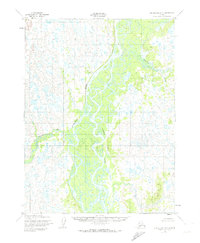
1952 Map of Dillingham A-5
USGS Topo · Published 1974About this map
The Nushagak River dominates this 1950s landscape, winding through an intricate network of sloughs and channels that characterize the Bristol Bay region. The presence of the Keefer Cutoff and the Iowithla River illustrates the dynamic hydrologic patterns of the era, where seasonal shifts and sediment transport constantly reshaped the navigable waterways. Human presence is minimal and temporary on this sheet, marked only by a solitary cabin near the riverbanks, suggesting a landscape primarily used for seasonal fishing or trapping rather than permanent settlement. The survey detail, including Koggiling Creek, provides a technical record of this wilderness as it was documented by the Corps of Engineers and the Geological Survey before contemporary infrastructure changes.
Find a feature on this map
5 named features on this map. Tap any name to fly to it.
Don’t see what you’re looking for? This feature index may not catch every label — zoom into the map to look around manually.
Map Details
Editions of this 1952 Dillingham A-5 Map
2 editions found
Other maps of this area

1951 · Dillingham
USGS Topo · 1:250,000

1952 · Naknek
USGS Topo · 1:250,000

1952 · Dillingham A-5
USGS Topo · 1:63,360

1952 · Dillingham A-4
USGS Topo · 1:63,360

1952 · Naknek D-5
USGS Topo · 1:63,360

1952 · Dillingham A-6
USGS Topo · 1:63,360

1952 · Naknek D-6
USGS Topo · 1:63,360

1954 · Dillingham
USGS Topo · 1:250,000

1954 · Dillingham B-4
USGS Topo · 1:63,360

1954 · Dillingham B-6
USGS Topo · 1:63,360