
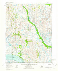
1952 Map of Dillingham A-6
USGS Topo · Published 1963About this map
The Nushagak River dominates the southern landscape of this 1952 Alaskan survey, where its tidal reaches meet expansive deposits of Sand and Mud along the shoreline. This coastal environment is defined by the shifting waters of the Kowithli River and the Little Muklung River, which meander through a labyrinth of small lakes and marshes. A prominent overland route, the Winter Trail, cuts across the tundra north of the Nushagak, providing a glimpse into the seasonal transport networks essential to this region before modern infrastructure. Near the river's bend, Lewis Pt stands as a distinct geographical marker, while the inland terrain is characterized by hundreds of unnamed ponds and intricate drainage patterns typical of the Dillingham quadrangle. The map reflects a period when land lines were largely unsurveyed, relying on photogrammetric methods from early 1950s aerial photography to document this remote delta system.
Find a feature on this map
7 named features on this map. Tap any name to fly to it.
Don’t see what you’re looking for? This feature index may not catch every label — zoom into the map to look around manually.
Map Details
Editions of this 1952 Dillingham A-6 Map
2 editions found
Other maps of this area

1945 · Nushagak Bay
USGS Topo · 1:250,000

1949 · Nushagak Bay
USGS Topo · 1:250,000

1951 · Dillingham
USGS Topo · 1:250,000

1951 · Nushagak Bay
USGS Topo · 1:250,000

1952 · Naknek
USGS Topo · 1:250,000

1952 · Dillingham A-5
USGS Topo · 1:63,360

1952 · Nushagak Bay D-1
USGS Topo · 1:63,360

1952 · Dillingham A-7
USGS Topo · 1:63,360

1952 · Naknek D-6
USGS Topo · 1:63,360

1954 · Dillingham
USGS Topo · 1:250,000