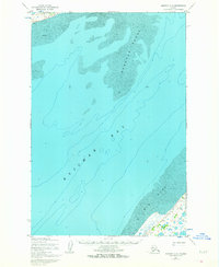
1952 Map of Naknek C-5
USGS Topo · Published 1964About this map
Kvichak Bay dominates this coastal survey, where the shifting bathymetry of Bristol Bay defines the landscape. The map illustrates a complex marine environment of Deadman Sands and the expansive Big Flat, documenting the intricate patterns of sand and mud that dictate navigation in these waters. On the southeastern shoreline, human presence is minimal but strategically positioned. A lone Cabin sits near the coast, connected to the interior by a Winter Trail. This overland route suggests the seasonal nature of movement and commerce in the region during the early 1950s, likely serving local hunters, trappers, or fishers who relied on frozen ground for transit. The hydrographic data, compiled from Usc&GS records, emphasizes the hazards of this tidal environment, where shoals and flats are constantly reshaped by the sea.
Find a feature on this map
8 named features on this map. Tap any name to fly to it.
Don’t see what you’re looking for? This feature index may not catch every label — zoom into the map to look around manually.
Map Details
Editions of this 1952 Naknek C-5 Map
2 editions found
Other maps of this area

1952 · Naknek
USGS Topo · 1:250,000

1952 · Naknek C-5
USGS Topo · 1:63,360

1952 · Naknek B-4
USGS Topo · 1:63,360

1952 · Naknek B-5
USGS Topo · 1:63,360

1952 · Naknek C-6
USGS Topo · 1:63,360

1952 · Naknek D-5
USGS Topo · 1:63,360

1952 · Naknek D-4
USGS Topo · 1:63,360

1952 · Naknek D-6
USGS Topo · 1:63,360

1952 · Naknek C-4
USGS Topo · 1:63,360

1964 · Naknek
USGS Topo · 1:250,000