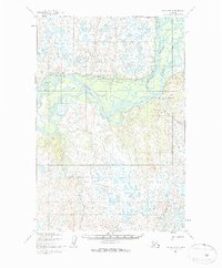
1952 Map of Naknek D-6
USGS Topo · Published 1963About this map
The Nushagak River dominates this mid-century landscape, carving a complex network of waterways through the Alaskan wilderness. Based on 1951 aerial photography and field-annotated in 1952, the map illustrates the dynamic nature of the river system, featuring the Scandinavian Slough and the Keefer Cutoff. These braided channels and oxbows represent a shifting environment where water and land are in constant flux.
Find a feature on this map
7 named features on this map. Tap any name to fly to it.
Don’t see what you’re looking for? This feature index may not catch every label — zoom into the map to look around manually.
Map Details
Editions of this 1952 Naknek D-6 Map
2 editions found

Other maps of this area

1945 · Nushagak Bay
USGS Topo · 1:250,000

1949 · Nushagak Bay
USGS Topo · 1:250,000

1951 · Dillingham
USGS Topo · 1:250,000

1951 · Nushagak Bay
USGS Topo · 1:250,000

1952 · Naknek
USGS Topo · 1:250,000

1952 · Dillingham A-5
USGS Topo · 1:63,360

1952 · Naknek C-5
USGS Topo · 1:63,360
1952 · Nushagak Bay C-1
USGS Topo · 1:63,360

1952 · Naknek C-6
USGS Topo · 1:63,360

1952 · Naknek D-5
USGS Topo · 1:63,360