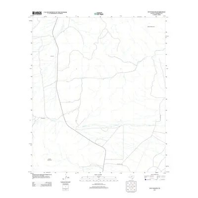
2013 Map of Nutt Ranch
USGS Topo · Published 2013About this map
Nutt Ranch and Puckett Ranch anchor this West Texas landscape, illustrating the enduring ranching culture of Culberson County. The terrain is defined by the significant elevations of the Baylor Mountains in the northeast and the Beach Mountains to the southwest, creating a broad valley corridor between these distinct ranges. The seasonal drainage of Sulphur Cr winds eastward across the center of the quadrangle, a vital geographical feature for water management in this arid environment. Transportation through the area is facilitated by the prominent route of State Highway 54 and the unpaved Whitehead Ho Rd, which provide access to isolated outposts like Watson Ranch. This 2013 survey offers a detailed perspective on contemporary land use and the sparse settlement patterns typical of the Trans-Pecos region.
Find a feature on this map
7 named features on this map. Tap any name to fly to it.
Don’t see what you’re looking for? This feature index may not catch every label — zoom into the map to look around manually.
Map Details
Editions of this 2013 Nutt Ranch Map
This is the sole edition of this map. No revisions or reprints were ever made.
Other maps of this area

1906 · Van Horn
USGS Topo · 1:125,000

1954 · Van Horn
USGS Topo · 1:250,000

1958 · Van Horn
USGS Topo · 1:250,000

1964 · Wild Horse
USGS Topo · 1:24,000
1964 · Hackett Peak
USGS Topo · 1:24,000

1964 · Watson Ranch
USGS Topo · 1:24,000

1964 · Van Horn
USGS Topo · 1:24,000
1964 · Sheep Peak
USGS Topo · 1:24,000
1964 · Nutt Ranch
USGS Topo · 1:24,000

1972 · Square Mesa
USGS Topo · 1:24,000