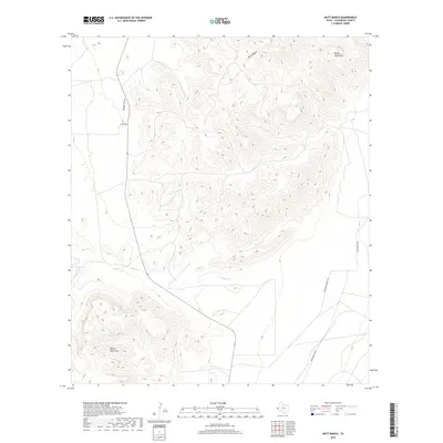
2019 Map of Nutt Ranch
USGS Topo · Published 2019About this map
Nutt Ranch serves as a primary human landmark in this section of West Texas, situated in the corridor between the Baylor Mountains to the north and the Beach Mountains to the south. The landscape is defined by its dramatic elevation changes and drainage patterns, including the prominent Baylor Draw and the course of Sulphur Creek. Transportation in this arid environment is limited to specialized routes such as Whitehead Hq Rd, which connects local ranching operations to the wider region. The map captures the specialized hydrology of the Trans-Pecos, where features like Bull Canyon reveal the complex erosion of the mountain blocks. This 2019 survey provides contemporary topography of Culberson County, showing the enduring footprint of ranching life in a geography of isolation.
Find a feature on this map
7 named features on this map. Tap any name to fly to it.
Don’t see what you’re looking for? This feature index may not catch every label — zoom into the map to look around manually.
Map Details
Editions of this 2019 Nutt Ranch Map
This is the sole edition of this map. No revisions or reprints were ever made.
Other maps of this area

1906 · Van Horn
USGS Topo · 1:125,000

1954 · Van Horn
USGS Topo · 1:250,000

1958 · Van Horn
USGS Topo · 1:250,000

1964 · Wild Horse
USGS Topo · 1:24,000
1964 · Hackett Peak
USGS Topo · 1:24,000

1964 · Watson Ranch
USGS Topo · 1:24,000

1964 · Van Horn
USGS Topo · 1:24,000
1964 · Sheep Peak
USGS Topo · 1:24,000
1964 · Nutt Ranch
USGS Topo · 1:24,000

1972 · Square Mesa
USGS Topo · 1:24,000