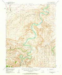
1953 Map of Nutters Hole
USGS Topo · Published 1963About this map
The Green River carves a dramatic, winding path through this portion of eastern Utah, creating a series of alluvial loops including Moon Bottom, Hydes Bottom, and Long Bottom. This mid-century survey documents a wilderness landscape defined by the deep incision of Desolation Canyon and the towering heights of the Roan or Brown Cliffs. Human presence is sparse, marked primarily by the Sand Wash Ferry (Site) and a lone Oil Well in the northern flats, illustrating the region's historical reliance on river crossings and nascent mineral exploration. The map provides clear boundary delineations for the Uinta Reservation and the Uncompahgre Addition, showing how tribal lands interface with the complex topography of Nutters Hole and the The Wrinkles. Numerous seasonal drainages like Nine Mile Creek and Tabyago Creek underscore the arid character of the high desert terrain.
Find a feature on this map
49 named features on this map. Tap any name to fly to it.
Don’t see what you’re looking for? This feature index may not catch every label — zoom into the map to look around manually.
Map Details
Editions of this 1953 Nutters Hole Map
3 editions found
Other maps of this area

1885 · East Tavaputs
USGS Topo · 1:250,000

1885 · Ashley
USGS Topo · 1:250,000

1885 · Uinta
USGS Topo · 1:250,000

1886 · Price River
USGS Topo · 1:250,000

1896 · Price River
USGS Topo · 1:250,000

1917 · Vernal
USGS Topo · 1:125,000

1939 · Duchesne
USGS Topo · 1:125,000

1953 · Nutters Hole
USGS Topo · 1:62,500

1953 · Firewater Canyon
USGS Topo · 1:62,500

1954 · Flat Canyon
USGS Topo · 1:62,500