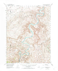
1953 Map of Nutters Hole
USGS Topo · Published 1974About this map
The Green River carves a deep, winding course through the Uinta Basin in this mid-century survey, creating a series of distinctive riverside flats known as bottoms. These fertile pockets, including Moon Bottom, Hydes Bottom, and Long Bottom, stand in sharp contrast to the surrounding desert landscape of Eightmile Flat and Horse Bench. The river's path through Desolation Canyon in the south reveals the complex geology of the region, specifically near the curious landform known as The Wrinkles.
Find a feature on this map
48 named features on this map. Tap any name to fly to it.
Don’t see what you’re looking for? This feature index may not catch every label — zoom into the map to look around manually.
Map Details
Editions of this 1953 Nutters Hole Map
3 editions found
Other maps of this area

1885 · East Tavaputs
USGS Topo · 1:250,000

1885 · Ashley
USGS Topo · 1:250,000

1885 · Uinta
USGS Topo · 1:250,000

1886 · Price River
USGS Topo · 1:250,000

1896 · Price River
USGS Topo · 1:250,000

1917 · Vernal
USGS Topo · 1:125,000

1939 · Duchesne
USGS Topo · 1:125,000

1953 · Nutters Hole
USGS Topo · 1:62,500

1953 · Firewater Canyon
USGS Topo · 1:62,500

1954 · Flat Canyon
USGS Topo · 1:62,500