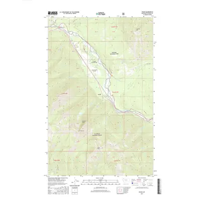
2017 Map of Nyack
USGS Topo · Published 2017About this map
The Middle Fork Flathead River carves a deep path through the northwestern Montana wilderness, serving as the primary corridor for movement between Glacier National Park and the Flathead National Forest. This river valley is dominated by high-elevation peaks including Loneman Mtn and Mt Penrose, which rise sharply from the water's edge. The settlement of Nyack sits at a critical junction within John F Stevens Canyon, where the landscape transitions toward the high alpine geography of Theodore Roosevelt Pass. Numerous tributaries, such as Nyack Cr and Skiumah Cr, feed the main river from the surrounding Flathead Range, while the Loneman Lookout provides a high-ground vantage point overlooking the southern boundary of the park.
Find a feature on this map
35 named features on this map. Tap any name to fly to it.
Don’t see what you’re looking for? This feature index may not catch every label — zoom into the map to look around manually.
Map Details
Editions of this 2017 Nyack Map
This is the sole edition of this map. No revisions or reprints were ever made.
Other maps of this area

1904 · Chief Mountain
USGS Topo · 1:125,000

1914 · Nyack
USGS Topo · 1:125,000

1938 · Chief Mountain
USGS Topo · 1:125,000

1960 · Cut Bank
USGS Topo · 1:250,000

1963 · Cut Bank
USGS Topo · 1:250,000

1964 · Cut Bank
USGS Topo · 1:250,000

1964 · Nyack
USGS Topo · 1:24,000

1964 · Pinnacle
USGS Topo · 1:24,000

1964 · Stanton Lake
USGS Topo · 1:24,000
1964 · Nyack SW
USGS Topo · 1:24,000