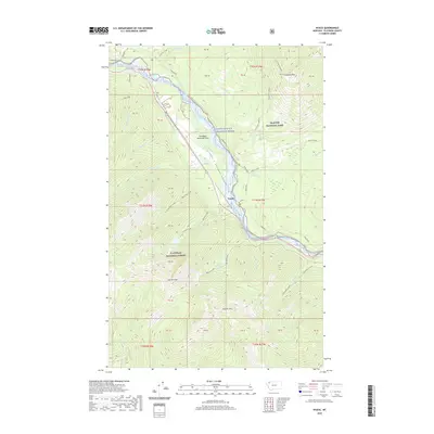
2020 Map of Nyack
USGS Topo · Published 2020About this map
The Middle Fork Flathead River serves as the central artery for this mountainous region, forming the southwestern boundary of Glacier National Park. The landscape is dominated by the narrow passage of John F Stevens Canyon, a critical corridor that funnels transportation through the high peaks. The small settlement of Nyack sits along the riverbank near the Nyack Crossing, positioned at the junction of several drainage systems including Nyack Cr and Rescue Cr.
Find a feature on this map
54 named features on this map. Tap any name to fly to it.
Don’t see what you’re looking for? This feature index may not catch every label — zoom into the map to look around manually.
Map Details
Editions of this 2020 Nyack Map
This is the sole edition of this map. No revisions or reprints were ever made.
Other maps of this area

1904 · Chief Mountain
USGS Topo · 1:125,000

1914 · Nyack
USGS Topo · 1:125,000

1938 · Chief Mountain
USGS Topo · 1:125,000

1960 · Cut Bank
USGS Topo · 1:250,000

1963 · Cut Bank
USGS Topo · 1:250,000

1964 · Cut Bank
USGS Topo · 1:250,000

1964 · Nyack
USGS Topo · 1:24,000

1964 · Pinnacle
USGS Topo · 1:24,000

1964 · Stanton Lake
USGS Topo · 1:24,000
1964 · Nyack SW
USGS Topo · 1:24,000