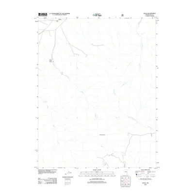
2012 Map of Nyala
USGS Topo · Published 2012About this map
Nyala and the nearby Sharp Ranch anchor this high-desert landscape on the eastern edge of the Railroad Valley during the early 21st century. The terrain is defined by the dramatic rise toward Troy Mountain in the southeast, with numerous seasonal drainages such as Little Cherry Cr, Hooper Cr, and Pine Cr cutting through the alluvial fans. To the west, the topography transitions into the steep corridors of Willow Creek Canyon, where Willow Cr and Big Cr descend from the higher elevations. The presence of isolated water sources like Monitor Spring and Grouse Spring underscores the precarious nature of ranching and settlement in this arid Nye County environment. This survey captures a moment when traditional land use, represented by cattle ranching and remote outposts, persisted alongside the preservation of the surrounding wilderness areas.
Find a feature on this map
16 named features on this map. Tap any name to fly to it.
Don’t see what you’re looking for? This feature index may not catch every label — zoom into the map to look around manually.
Map Details
Editions of this 2012 Nyala Map
This is the sole edition of this map. No revisions or reprints were ever made.
Other maps of this area

1956 · Lund
USGS Topo · 1:250,000

1960 · Lund
USGS Topo · 1:250,000

1964 · Troy Canyon
USGS Topo · 1:62,500

1968 · The Wall
USGS Topo · 1:62,500
1968 · The Wall SE
USGS Topo · 1:24,000

1985 · Adaven
USGS Topo · 1:24,000
1985 · Goat Ranch Springs
USGS Topo · 1:24,000
1985 · Big Creek Ranch
USGS Topo · 1:24,000
1985 · Badger Gulch
USGS Topo · 1:24,000
1985 · Wadsworth Ranch
USGS Topo · 1:24,000