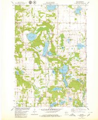
1978 Map of Nye
USGS Topo · Published 1979About this map
Glacial topography defines this corner of Polk County, where dozens of kettle lakes and wetlands are interspersed with small dairy-country settlements and rural parishes. Near the center of the map, the village of Nye sits along the Soo Line railroad, south of the extensive Behning Creek State Public Fishing Area and Horse Lake. The landscape is dotted with generational landmarks essential for genealogists, including Sand Lake Cem, El Salem Cem, and West Immanuel Ch. The drainage patterns are dominated by Horse Creek and the Apple River in the southeast, while extractive industries like the Quarry near Round Lake and various sandpits reflect the local geology. Recreation and conservation are evident at Lotus Lake County Park, which borders the larger Lotus Lake.
Find a feature on this map
47 named features on this map. Tap any name to fly to it.
Don’t see what you’re looking for? This feature index may not catch every label — zoom into the map to look around manually.
Map Details
Editions of this 1978 Nye Map
This is the sole edition of this map. No revisions or reprints were ever made.
Other maps of this area

1900 · St Croix Dalles
USGS Topo · 1:62,500

1901 · St Croix Dalles
USGS Topo · 1:62,500

1948 · New Richmond
USGS Topo · 1:62,500

1949 · New Richmond
USGS Topo · 1:62,500

1950 · Deer Park
USGS Topo · 1:62,500

1950 · Balsam Lake
USGS Topo · 1:62,500

1953 · Stillwater
USGS Topo · 1:250,000

1955 · St. Croix Dalles
USGS Topo · 1:62,500

1955 · Stillwater
USGS Topo · 1:250,000

1958 · Stillwater
USGS Topo · 1:250,000