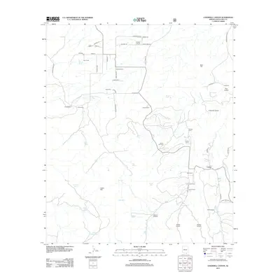
2012 Map of O'Donnell Canyon
USGS Topo · Published 2012About this map
Canelo sits at the heart of this high-desert ranching landscape in Santa Cruz County, where the southern foothills of the Canelo Hills meet a network of cattle tanks and remote canyons. This 2012 survey documents a long-standing ranching economy, represented by the scattered operations of Houston Ranch, Roath Ranch, and the Canelo Hills Ranch. Water management is the defining human imprint on this arid terrain, with numerous man-made features such as Cemetery Tank, Pinto Tank, and Lampshire Tank providing essential resources for livestock. The burial ground at Black Oak Cem serves as a small but significant historical marker for the families who settled this region near the border. Drainage patterns are dominated by O'Donnell Canyon and the headwaters of Turkey Cr, creating a rugged topography that has dictated the placement of historic homesteads like the Umpire Ranch and Frazier Ranch.
Find a feature on this map
65 named features on this map. Tap any name to fly to it.
Don’t see what you’re looking for? This feature index may not catch every label — zoom into the map to look around manually.
Map Details
Editions of this 2012 O'Donnell Canyon Map
This is the sole edition of this map. No revisions or reprints were ever made.
Other maps of this area

1904 · Patagonia
USGS Topo · 1:125,000

1905 · Patagonia
USGS Topo · 1:125,000

1905 · Nogales
USGS Topo · 1:125,000

1914 · Hereford
USGS Topo · 1:125,000

1915 · Benson
USGS Topo · 1:125,000

1922 · Sunnyside
USGS Topo · 1:62,500

1932 · Lochiel
USGS Topo · 1:62,500

1932 · Elgin
USGS Topo · 1:62,500

1938 · Huachuca
USGS Topo · 1:62,500

1938 · Sunnyside
USGS Topo · 1:62,500