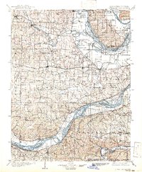
1903 Map of O'Fallon
USGS Topo · Published 1941About this map
Mississippi River and Missouri River bottomlands converge in this turn-of-the-century survey of the rugged confluence region. The landscape is defined by its complex hydrology, featuring numerous oxbows like Horseshoe Lake and Merry Rundo Lake, alongside the strategic elevated terrain of Elm Point and Tavern Rock. Early railroad development is central to the area's growth, with the Wabash RR and the Keokuk St. Louis and Northwestern RR cutting through established river towns and farming communities.
Find a feature on this map
134 named features on this map. Tap any name to fly to it.
Don’t see what you’re looking for? This feature index may not catch every label — zoom into the map to look around manually.
Map Details
Editions of this 1903 O'Fallon Map
5 editions found
Other maps of this area

1890 · Louisiana
USGS Topo · 1:125,000

1890 · Hermann
USGS Topo · 1:125,000

1901 · De Soto
USGS Topo · 1:125,000

1903 · O'Fallon
USGS Topo · 1:125,000

1903 · Sullivan
USGS Topo · 1:125,000

1912 · Kimmswick
USGS Topo · 1:62,500

1916 · Kimmswick
USGS Topo · 1:62,500

1924 · Robertson
USGS Topo · 1:24,000

1927 · St. Charles
USGS Topo · 1:62,500

1930 · Hardin
USGS Topo · 1:62,500