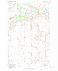
1953 Map of O'Hanlon Coulee
USGS Topo · Published 1977About this map
The Missouri River and Teton River converge in this northern Montana landscape, where the meandering waterways have carved a complex system of bars and bends, including Evans Bend and Shonkin Bar. The topography is dominated by the deeply incised O'Hanlon Coulee and Early Coulee, which drain the elevated Rowe Bench toward the river valley. This 1950s survey captures a rural cattle-ranching economy defined by family holdings such as the Carl O'Hara Ranch, Streit Ranch, and Stevenson Ranch. Transportation and education for these isolated homesteads centered on the Great Northern railroad line and the Rode School. The terrain rises toward the south at Frenchmans Ridge, providing a clear view of the transition from the river bottomlands to the high plains breaks.
Find a feature on this map
27 named features on this map. Tap any name to fly to it.
Don’t see what you’re looking for? This feature index may not catch every label — zoom into the map to look around manually.
Map Details
Editions of this 1953 O'Hanlon Coulee Map
2 editions found
Other maps of this area

1890 · Fort Benton
USGS Topo · 1:250,000

1892 · Fort Benton
USGS Topo · 1:250,000

1897 · Fort Benton
USGS Topo · 1:250,000

1953 · Rocky Lake
USGS Topo · 1:24,000

1953 · Loma East
USGS Topo · 1:24,000

1953 · O'Hanlon Coulee
USGS Topo · 1:24,000

1953 · Loma West
USGS Topo · 1:24,000

1954 · Great Falls
USGS Topo · 1:250,000

1954 · Fort Benton
USGS Topo · 1:24,000

1957 · Great Falls
USGS Topo · 1:250,000