
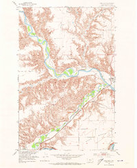
1953 Map of Loma West
USGS Topo · Published 1955About this map
The Marias River and Teton River converge toward the Missouri River in this mid-century survey of Chouteau County. The landscape is defined by significant elevation shifts between the high Rowe Bench and the carved valleys of the Dry Fork Coulee and Chip Creek. Transportation and settlement patterns follow the water, with the Great Northern railroad line cutting through the Teton valley to serve Teton Station and the small community of Loma. Local history is captured in the presence of the Collins Sch (Aband) and family-named landmarks like Cracon du nez. The map illustrates a ranching and rail-dependent economy during a period of transition, noting landmarks such as a isolated Windmill and the river navigation point at Brule Bar.
Find a feature on this map
17 named features on this map. Tap any name to fly to it.
Don’t see what you’re looking for? This feature index may not catch every label — zoom into the map to look around manually.
Map Details
Editions of this 1953 Loma West Map
2 editions found
Other maps of this area

1890 · Fort Benton
USGS Topo · 1:250,000

1892 · Fort Benton
USGS Topo · 1:250,000

1897 · Fort Benton
USGS Topo · 1:250,000

1919 · Big Sandy
USGS Topo · 1:125,000

1953 · Rocky Lake
USGS Topo · 1:24,000

1953 · Loma East
USGS Topo · 1:24,000

1953 · O'Hanlon Coulee
USGS Topo · 1:24,000

1954 · Great Falls
USGS Topo · 1:250,000

1954 · Fort Benton
USGS Topo · 1:24,000

1954 · Shelby
USGS Topo · 1:250,000