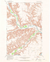
1953 Map of Loma West
USGS Topo · Published 1973About this map
The confluence of three major waterways—the Marias River, the Teton River, and the Missouri River—shapes the landscape of this Chouteau County region. Surveyed in the early 1950s, the map illustrates a river-and-rail corridor critical to Montana’s agricultural transport. The Great Northern Railroad tracks run parallel to the Teton, connecting small outposts like Teton Station and the town of Loma, where a Post Office is located.
Find a feature on this map
14 named features on this map. Tap any name to fly to it.
Don’t see what you’re looking for? This feature index may not catch every label — zoom into the map to look around manually.
Map Details
Editions of this 1953 Loma West Map
2 editions found
Other maps of this area

1890 · Fort Benton
USGS Topo · 1:250,000

1892 · Fort Benton
USGS Topo · 1:250,000

1897 · Fort Benton
USGS Topo · 1:250,000

1919 · Big Sandy
USGS Topo · 1:125,000

1953 · Rocky Lake
USGS Topo · 1:24,000

1953 · Loma East
USGS Topo · 1:24,000

1953 · O'Hanlon Coulee
USGS Topo · 1:24,000

1953 · Loma West
USGS Topo · 1:24,000

1954 · Great Falls
USGS Topo · 1:250,000

1954 · Fort Benton
USGS Topo · 1:24,000