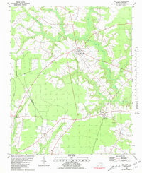
1981 Map of Oak City
USGS Topo · Published 1981About this map
Oak City and the neighboring community of Hassell anchor this survey of the low-lying coastal plain along the boundary of Martin and Edgecombe counties. The landscape is defined by the slow-moving waters of Conoho Creek, Crisp Creek, and Etheridge Swamp, which dictate the placement of local roads and the Seaboard Coast Line railroad. This environment fostered a dispersed settlement pattern centered on rural spiritual life, with numerous landmarks such as Merritts Chapel, Victory Mission, and Hatties Chapel appearing throughout the quadrangle.
Find a feature on this map
17 named features on this map. Tap any name to fly to it.
Don’t see what you’re looking for? This feature index may not catch every label — zoom into the map to look around manually.
Map Details
Editions of this 1981 Oak City Map
This is the sole edition of this map. No revisions or reprints were ever made.
Other maps of this area

1901 · Parmele
USGS Topo · 1:62,500

1901 · Williamston
USGS Topo · 1:62,500

1902 · Williamston
USGS Topo · 1:62,500

1902 · Parmele
USGS Topo · 1:62,500

1953 · Norfolk
USGS Topo · 1:250,000

1953 · Rocky Mount
USGS Topo · 1:250,000

1954 · Rocky Mount
USGS Topo · 1:250,000

1962 · Palmyra
USGS Topo · 1:24,000

1962 · Hobgood
USGS Topo · 1:24,000

1972 · Woodville
USGS Topo · 1:24,000