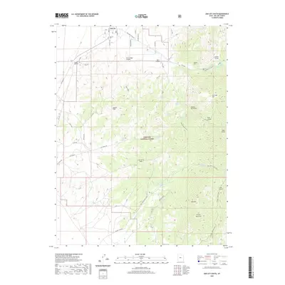
2020 Map of Oak City South
USGS Topo · Published 2020About this map
Oak City anchors the northern edge of this high-altitude landscape, where the town’s grid meets the rising slopes of the Canyon Mountains. Just south of the settlement, Jack Hill and Bald Hill overlook a complex network of canyons and ridges defined by seasonal drainages like Sixmile Wash and Clay Spring Wash. Much of the terrain is protected within the Fishlake National Forest, a region characterized by numerous named water sources including Quaking Asp Spring, Maple Spring, and Whisky Spring. The eastern half of the map is dominated by high peaks such as Partridge Mtn and Blue Mtn, with a system of forest trails like Trail 1411 and Trail 1378 providing access to the more remote heights. This survey details the transition from the irrigated valley floors near the Oak City Cem to the heavily forested and spring-fed canyons that descend from the higher reaches of the range.
Find a feature on this map
56 named features on this map. Tap any name to fly to it.
Don’t see what you’re looking for? This feature index may not catch every label — zoom into the map to look around manually.
Map Details
Editions of this 2020 Oak City South Map
This is the sole edition of this map. No revisions or reprints were ever made.
Other maps of this area

1885 · Sevier Desert
USGS Topo · 1:250,000

1951 · Oak City
USGS Topo · 1:62,500

1952 · Scipio North
USGS Topo · 1:62,500

1953 · Delta
USGS Topo · 1:250,000

1958 · Delta
USGS Topo · 1:250,000

1962 · Delta
USGS Topo · 1:250,000

1962 · Holden
USGS Topo · 1:62,500
1969 · Scipio Pass
USGS Topo · 1:24,000
1985 · Harding
USGS Topo · 1:24,000
1985 · Oak City North
USGS Topo · 1:24,000