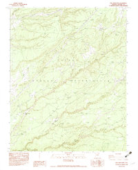
1983 Map of Oak Creek Mtn
USGS Topo · Published 1983About this map
Oak Creek Mtn. dominates this high-altitude landscape within the Navajo Indian Reservation during the early 1980s. The topography is defined by a complex network of seasonal drainages and ephemeral water sources, most notably the winding Yellow Lone Tule Wash and Black Soil Wash. The presence of Tseja-Kinsikadi Spring and Black Soil Spring suggests vital water points in an otherwise arid terrain. While human habitation is sparse, the infrastructure of the era is represented by Steel Tower Power Lines that cut across the plateau. The various named washes, such as Sage House Wash and Ruin Wash, hint at a landscape that has long supported local populations, with names reflecting both natural features and historical sites of interest to researchers of the region's geography.
Find a feature on this map
14 named features on this map. Tap any name to fly to it.
Don’t see what you’re looking for? This feature index may not catch every label — zoom into the map to look around manually.
Map Details
Editions of this 1983 Oak Creek Mtn Map
This is the sole edition of this map. No revisions or reprints were ever made.
Other maps of this area

1886 · Fort Defiance
USGS Topo · 1:250,000

1892 · Fort Defiance
USGS Topo · 1:250,000

1954 · Gallup
USGS Topo · 1:250,000

1955 · Zith-Tusayan Butte 3 NW
USGS Topo · 1:24,000

1955 · Zith-Tusayan Butte 2 SE
USGS Topo · 1:24,000

1955 · Zith-Tusayan Butte 4 NW
USGS Topo · 1:24,000

1955 · Zith-Tusayan Butte 2 SW
USGS Topo · 1:24,000

1955 · Zith-Tusayan Butte 3 NE
USGS Topo · 1:24,000

1955 · Zith-Tusayan Butte 2 NW
USGS Topo · 1:24,000

1955 · Zith-Tusayan Butte 2 NE
USGS Topo · 1:24,000