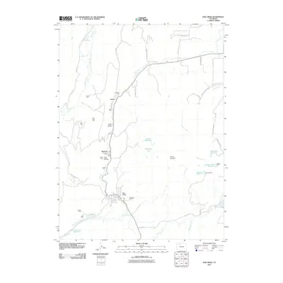
2010 Map of Oak Creek
USGS Topo · Published 2010About this map
Oak Creek serves as the focal point of this region, which was historically defined by its extensive coal mining operations and complex water management. The landscape is dotted with evidence of industrial heritage, from the Keystone Mine and Haybro Mine to the Edna Strip Mine, illustrating the intense extraction that once shaped the local economy. These mines are concentrated along the north-south axis of the creek, which also supports a network of agricultural and municipal infrastructure. Several irrigation ditches, including the Homestead Ditch and Rossi Highline Ditch, suggest a legacy of water rights and land use tension. The eastern half of the map rises toward Thorpe Mountain, where high-altitude water storage such as Henderson Reservoir and Overman Reservoir feeds into the Yampa River valley. The presence of the Oak Creek Cemetery and small clusters at Haybro provide essential reference points for genealogists researching families tied to these Routt County mining communities.
Find a feature on this map
57 named features on this map. Tap any name to fly to it.
Don’t see what you’re looking for? This feature index may not catch every label — zoom into the map to look around manually.
Map Details
Editions of this 2010 Oak Creek Map
This is the sole edition of this map. No revisions or reprints were ever made.
Other maps of this area

1924 · Mt. Harris
USGS Topo · 1:48,000

1926 · Mount Harris
USGS Topo · 1:62,500

1954 · Craig
USGS Topo · 1:250,000

1957 · Craig
USGS Topo · 1:250,000

1958 · Craig
USGS Topo · 1:250,000

1960 · Craig
USGS Topo · 1:250,000

1962 · Craig
USGS Topo · 1:250,000

1964 · Craig
USGS Topo · 1:250,000

1965 · Craig
USGS Topo · 1:250,000
1966 · Sand Point
USGS Topo · 1:24,000